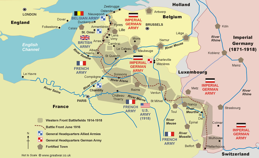
WW1 Battlefields of the Western Front
The long line of battlefields that makes up the Western Front runs through a wide variety of landscapes in south-west Belgium, north-eastern and eastern France. The battle lines wind their way across the countryside from the sand dunes and flat, reclaimed sea level land on the Belgian coast in the north, to the mountain peaks at 1,400 metres (4,500 feet) above sea level in the Vosges mountain range at its southern end.
From a geographical point of view the range of landscapes on which the Western Front battlefields were established include sand, clay, chalk and rock, rivers, canals, valleys and cliffs, ridges and mountains, plains, forests and swamps. When visiting the battlefields it can be seen how the geological make-up of the ground and the peculiarities of the landscape inevitably played a major part in influencing strategy, tactics, development of new weaponry and fighting techniques in the battles of the Western Front.
- Western Front Map
- Belgian Wallonia: Liège, Namur and Mons
- Antwerp
- The Belgian Coast
- Belgian Flanders: The Yser
- Belgian Flanders: the Ypres Salient
- French Flanders
- Artois: La Bassée-Lens
- Artois: Loretto Heights and Vimy Ridge
- Artois: Arras
- Picardy: The Somme
- Cambrai (Flanders)
- French Flanders/Picardy: Maubeuge to St. Quentin
- Aisne (Picardy)
- Marne (Champagne)
- Champagne
- Lorraine: Verdun
- Lorraine: St. Mihiel Salient
- Lorraine: Moselle and Meurthe
- Alsace: Vosges Mountains
- Alsace: Rhine Plain
Map of the 1914-1918 Western Front Battlefields
The grey shaded areas on the map illustrate the battlefield areas of the 1914-1918 Western Front from its northern end on the Belgian coast to the village of Pfetterhouse on the Swiss frontier at its southern end. The map shows the Franco-German border as it was in 1914 when the war broke out.
A brief description of the main battlefield locations is given below the map, or hover over a grey-shaded area and click to take you to the relevant description below.
Belgian Wallonia: Liège, Namur and Mons
![]() |
The Imperial German Army crossed the border into neutral Belgium and the French-speaking Walloon region on 4th August 1914. Following the fall of the fortified city of Liège on 7th August the German advance continued through the economically prosperous industrial region of south-east Belgium along the Meuse and Sambre river valleys. At the time this region in south-east Belgium was a wealthy one, benefitting from industrialisation as a result of the rich iron and coal deposits there. The fortifications of the city of Namur could not hold out against the German attack on the 21st and the town was taken by German forces on 25th August.
The area north and east of the town of Mons was the location where the British Expeditionary Force first encountered the advancing German Imperial forces on 23rd August 1914. This was the first battle in the First World War between the British Army and the Imperial German Army. Following the British withdrawal to the south from 24th August Mons was occupied by the Germans for four years until it was recaptured on 11th November 1918.
Battles of the Western Front 1914-1918: 1914 First Encounters and Battles of the Frontiers
Antwerp
![]() |
The port of Antwerp is located in the north of Belgium at the mouth of the Scheldt river. In 1914 Antwerp, one of the most important ports in the world even at that time, was surrounded by a defensive ring of 22 garrisoned fortresses with smaller redoubts between them. On 17th August 1914 the Belgian government was forced to leave Brussels when the Belgian capital was threatened by the Imperial German Army's advance on that city. The Belgian government relocated to Antwerp as part of a pre-determined national plan. The forts were intended to protect the city and those Belgian forces making a stand behind the defenses.
Following the fall of Liège most of the Belgian Field Army fell back to the fortifications of Antwerp. The city lay under siege for 15 days, during which time the German Army brought in very large siege guns to smash the forts. The British Royal Naval Division was sent to assist the Belgian King Albert and his military forces defending the city. However, the Belgian and British forces were forced to make a withdrawal from Antwerp, which was taken by the Germans on 10th October. The city was occupied by German forces for exactly four years until it was reoccupied by Belgian forces on 19th November 1918.
Battles of the Western Front 1914-1918: 1914 Siege of Antwerp
The Belgian Coast
![]() |
During the four year German occupation of the Belgian coast the sandy coastline from Zeebrugge to Nieupoort was heavily fortified. This was the most northerly part of Imperial Germany's Western Front, exposed and vulnerable by it's proximity to the sea. Numerous concrete gun battery emplacements were built in the sand dunes to defend against bombardments from the British Royal Navy. The German batteries consisted of enormous blockhouses, armour-protected guns, personnel and ammunition shelters and anti-aircraft machine-gun posts.
Battles of the Western Front 1914-1918: 1914 Battles in the “Race to the Sea”
Belgian Flanders: The Yser
|
The battlefield of the Yser is located close to the English Channel at the northern end of The Western Front. It is situated in the north-west region of the Flemish province of West-Flanders (also known as Flanders) in Belgium. The Yser battlefield covers the area from the Belgian coast at Nieuwpoort to the village of Bikschote. In order to block the Imperial German Army's advance towards the Channel ports of Dunkerque and Calais in mid October 1914 the decision was taken to flood the land to the east of the river Yser. The sluice gates were opened at Nieuwpoort and the sea water was deliberately allowed to flood this reclaimed, low-lying area of Flanders, thereby preventing the German Army from continuing the fight in this sector.
Battles of the Western Front 1914-1918: 1914 Battles in the “Race to the Sea”
Belgian Flanders: the Ypres Salient
|
The battlefields of the Ypres Salient are situated in the south-west of the Flemish province of West-Flanders in Belgium. The battlefield area lies between Bikschote village at its northern end and the Ploegsteert forest (known as Plugstreet Wood to British Army) at its southern end.
The fighting arrived in the area north, east and south of the city of Ypres from September 1914. Following the successful defence of the city by French and British forces in October and November 1914 the German advance to the ports of Dunkirk and Calais was halted east of the city. The German army consolidated a defensive line located along a semi-circular ridge of favourable high ground. This offered a natural defensive platform for the Germans to surround the northern, eastern and southern perimeter of a bulge in the Allied line. This bulge into the enemy position is known as a “salient” in military terminology. The German positions overlooked the Allied armies in the lower-lying ground of the salient. From the vantage point of the ridge, the German army was equally determined to prevent the Allies gaining a foothold on the ridge and the views it afforded into the German rear areas.
This battlefield sector became known to the British Army as The Ypres Salient. To the German Army it was known as the “Ypres Sack”.
Battles of the Western Front 1914-1918: 1914 Battles in the “Race to the Sea”
French Flanders
|
South of Ploegsteert forest the line of battlefields of the Western Front cross the Belgian border into France, continuing east of Armentières and on to the south-east of Lille. Formerly called French Flanders, this area now lies in the modern-day department of Nord in the region of Nord-Pas-de-Calais.
French Flanders is made up of two regions. The northerly region of French Westhoek between the North Sea and the Lys River is characterised as a flat, fertile, marshy plain criss-crossed by streams and ditches.
The southerly region south of the Lys River called Lille Flanders is the industrial, coal-mining area around Lille and Douai. In 1914 this industrial region was supplying 80% of the coal to the French nation. For this reason it was a vital area for the German Army to occupy; the coal could be mined and used by the German Army and the German homeland. In so doing it would prevent the French nation from having access to its usual supply of coal. The area was important to the German Army also because it was well served as a focus for major transportation routes in the form of railways, canals and roads.
Battles of the Western Front 1914-1918: 1914 Battles in the “Race to the Sea”
Battles of the Western Front 1914-1918: 1918 German Offensives to Break the Deadlock
Artois: La Bassée-Lens
|
The former historic province of Artois forms the eastern half of the modern-day department of Pas-de-Calais. This department lies within the larger region of Nord-Pas-de-Calais. The former province of Artois corresponds approximately to an area covered by the modern-day districts of Saint Omer, Béthune, Lens and Arras.
The area between the canal at La Bassée to Lens was an area of coalfields characterized by pit-heads, slag heaps and clustered ‘cities’ of terraced miners' cottages near the pits. The Front Lines passed through the western edge of the Lens industrial area.
Battles of the Western Front 1914-1918: 1915 Battles for a Breakthrough
Artois: Loretto Heights and Vimy Ridge
|
South of the coalfields around Lens the Artois landscape gently rises up in finger-like spurs. Two spurs of particularly high ground afford magnificent views in all directions. These spurs lie in a north-west to south-east direction. They are located north-west of the city of Arras and are known as the Loretto Heights and the Vimy ridge. Whichever force occupied the summits of these two ridges was in a position not only to have far-reaching views into the enemy's territory but also was able to protect the view across his own rear area. On a very clear day the range of hills south-west of the Ypres Salient in Belgium - the Mont Noir (Black Mountain) and the Rodeberg (Red Mountain) - can be seen from these heights. Costly battles took place for the possession of these two spurs with heavy casualties on both sides.
Artois: Arras
The south-eastern end of the Vimy Ridge descends into a gently rolling landscape following a low ridge to the east of the ancient city of Arras. East of Arras the Front Lines crossed gently rolling farmland, dotted with farms and villages.
Arras was evacuated by French forces on 29th August 1914 but reoccupied a month later. It remained in French hands throughout the war. Underneath the city there were tunnels and catacombs dug out of the chalk by the Romans. Some were used during the First World War by medical units and as safe shelter for Allied troops. The city was smashed to pieces by German artillery bombardments.
Battles of the Western Front 1914-1918: 1914 Battles in the “Race to the Sea”
Picardy: The Somme
|
South of Arras the Front Lines of the Western Front crossed the rolling, rural chalk downs of the province of Picardy to the marshy valley of the River Somme and the Canal de la Somme.
Having arrived in this sector in late September 1914, the German Army's further advance was halted north of the town of Albert by a stubborn French defence. The combination of an undulating landscape and the chalky ground provided the German divisions here with an opportunity to create a secure defensive line. It became known in the German Army as one of the best constructed defensive lines on the Western Front. Mining into the chalk the German troops built deep bunkers and tunnels to provide protection for large numbers of men. A careful selection of high ground early on in the autumn of 1914 provided advantageous views of the enemy's lines.
The Somme battlefield north and south of the river Somme was the location of three major offensives during the First World War; the Battle of the Somme in the summer of 1916, the German Spring Offensive in March 1918 and the Allied Advance to Victory in the summer of 1918.
Battles of the Western Front 1914-1918: 1916 Grinding Battles of Attrition: Verdun and the Somme
Battles of the Western Front 1914-1918: 1918 German Offensives to Break the Deadlock
Battles of the Western Front 1914-1918: 1918 Allied Advance to Victory: 100 Days Offensive
Battles of the Somme 1914-1918
Cambrai (Flanders)
Cambrai is a fortified town in the Department of Nord within the region of Nord-Pas-de-Calais of northern France. In the middle ages Cambrai cathedral was the seat of the bishops of Cambrai, who had jurisdiction over a very large Roman Catholic diocese in the historica province of French Flanders. There were 41 abbeys in the diocese. It was a wealthy place, known for the manufacture of muslin and a fine linen called Cambric and as a musical centre of excellence until the 15th century.
Later in its history Cambrai was the location where the Duke of Wellington had his headquarters from 1815 to 1818 during the British occupation in France. Some 100 years later, during the occupation of the town by the Imperial German Army, it was a headquarters for the German Supreme Command, also in occupation in parts of France. Strategically Cambrai occupied an important position as a railhead and junction for supplying the German Armies on the Western Front.
The area south-west of Cambrai witnessed a surprise attack on the heavily defended German positions of The Hindenburg Line. This section of The Hindenburg Line was called the “Siegfried Stellung” by the German Army. In November 1917 this battlefield witnessed the first large-scale use of tanks in a combined operation with artillery in the First World War.
Battles of the Western Front 1914-1918: 1917 First Allied Mass Tank Attack
French Flanders/Picardy: Maubeuge to St. Quentin
|
The distance between the towns of Maubeuge and St. Quentin is approximately 50 miles. The northern town of Maubeuge is located in the modern-day region of Nord-Pas-de-Calais (formerly French Flanders). The southern town of St. Quentin is located in the modern-day region of Picardy (also formerly the province of Picardy). The ground between these towns witnessed fighting in the early days of the war and the last weeks of the war.
On 25th August 1914 the German Army progressed its successful advance from Mons in Belgium, crossing the border into northern France following the retreat of the British Expeditionary Force to the south-west. In the last few weeks of the war the fighting returned to the area between St. Quentin and Maubeuge from September to November 1918. This time, however, the Allied Armies were hard on the heels of a withdrawing Imperial German Army.
The town of Le Cateau is situated in the historic area of French Flanders close to the Belgian border. Nowadays the town is in the commune of Le Cateau-Cambrésis in the region of Nord-Pas-de-Calais. The area west of Le Cateau was the location where the British II Corps made a stand on 26th August 1914 against the advancing German First Army, inflicting heavy losses on the enemy force. This enabled the British I Corps to make an organized withdrawal to the south.
On 29th August 1914 the area around St. Quentin was the location of a counter-offensive against the German advance by French forces and some British units of the British Expeditionary Force. The battle succeeded in stalling the German advance but did not stop it. St. Quentin was occupied by the German Army for the next four years. In March 1918 the area of St. Quentin was the jumping off point for Operation Michael, the first of a series of offensives by the German Army to attempt to finally break through the Allied front. Six months later at the end of September 1918 the Allied Forces of the United Kingdom, Australia and the United States made a successful attack against the heavily defended Hindenburg Line (this section was named the “Siegfried Stellung” by the German Army) at the St. Quentin canal north of St. Quentin. Within a few days the Allied force had broken through the Hindenburg Line and secured a good position from which to continue an advance towards Maubeuge and the Belgian border.
In the first few days of November 1918 the area south-west of Maubeuge was witness to an advance by French and British forces, which was to be one of the final offensives of the First World War. On 4th November the Sambre Canal was crossed with heavy casualties, but a breach in the German line was created. Together with French successes further south and American successes in the Argonne Forest area, the Allied advance continued to the north, recapturing French and Belgian soil lost to the German occupation four years before.
Battles of the Western Front 1914-1918: 1914 First Encounters and Battles of the Frontiers
Battles of the Western Front 1914-1918: 1918 Allied Advance to Victory: 100 Days Offensive
Aisne (Picardy)
|
The battlefields of the Aisne are located in a rural, agricultural and wooded landscape characterized by a high ridge and plateau known as the “Chemin des Dames”. The ridge is approximately 20 miles long and lies in an east-west direction between the valleys of the river Aisne to its south and the river Ailette to its north. The ridge is located in the department of the Aisne, which is one of the three modern-day departments within the historical province of Picardy.
The name of the ridge - which translates into English as the “Ladies' Path” or “Ladies' Way” - originates from the fact that two of the daughters of King Louis XV, Adélaide and Victoria, regularly visited their governess at the Château de la Bove, west of Craonne. As daughters of the King they were known as “Mesdames de France” - “Ladies of France”. The route along the ridge to the château north of the Aisne river provided a good and more direct route from the Royal Court in Paris. The road was cobbled to provide a better surface for the royal carriages.
The ridge had been a strategically important position for military leaders over the centuries even before the Imperial German Army arrived in the region of the Aisne in the autumn of 1914. Julius Caesar fought the Belgae here in 57 BC during the Gallic War. Napoléon Bonaparte fought the Russians at the Battle of Craonne in March 1814. The importance of the ridge was that it provided a west to east transportation route situated on high ground with excellent views to the north and south. It also formed a natural geographical barrier north-east of Paris, for which reason it became a prized strategic height for the French Army to want to control.
Battles of the Western Front 1914-1918: 1914 The Germans Entrench their Positions on the Aisne
Battles of the Western Front 1914-1918: 1918 German Offensives to Break the Deadlock
Marne (Champagne)
The department of the Marne is located in the historic province of Champagne. The western part of the Marne is hilly and wooded. The eastern part consists of a chalk plain. This area was well-known to the French Army of 1914, which had been using several military training grounds in the region for many years.
The Marne area was witness to two Allied victories, almost exactly four years apart with the first in September 1914 and the second in July-August 1918. The outcome of both of these battles to the advantage of the Allies resulted in the turn of the tide of events for the Imperial German Army. In 1914 the French and British forces managed to stop the advance of the German Army within a few miles of Paris in the battle often called the “Miracle of the Marne”. In 1918 Allied divisions of French, American, British and Italian troops successfully countered a large-scale German offensive intended as a diversion to cover the preparations for an offensive in Flanders. The German offensive in Flanders was called off following its defeat on the Marne battlefield.
Battles of the Western Front 1914-1918: 1914 German Advance Blocked at the Marne
Battles of the Western Front 1914-1918: 1918 German Offensives to Break the Deadlock
Champagne
|
Nowadays the historic province of Champagne is called Champagne-Ardenne. The front lines remained in the same location on the undulating chalk plain north of the ancient city of Reims for most of the war.
The city of Reims, close to the front lines, was occupied by German forces during the advance to the Marne river from 5th September 1914. The occupation only lasted a few days as the Imperial German Army was held by Allied forces at the Marne river and was forced to withdraw, evacuating Reims on 14th September. The city was badly damaged by German artillery bombardments by the end of the war. The famous Cathedral Notre-Dame de Reims, place of the coronation of the Kings of France over the centuries, was severely damaged by artillery bombardments beginning on 19th August 1914. In the early bombardments of autumn 1914 wooden scaffolding on the building caught on fire, adding to the destruction. Images of the cathedral in ruins were used during the war as propaganda images by the French against the German deliberate destruction of French buildings rich in national and cultural heritage. During the war the many underground caves cut into the chalk under the city, normally used as the famed champagne cellars of the region, provided shelter for the local people and French Army alike.
Battles of the Western Front 1914-1918: 1915 Battles for a Breakthrough
Lorraine: Verdun
|
The city of Verdun is located on the Meuse river in the Department of Meuse. It lies within the province of Lorraine, formerly the historic Duchy of Upper Lorraine. Verdun is surrounded by hills and lies in a strategic position on the river Meuse, forming a gateway through the valley to the plains of the Champagne. After the defeat of France in the Franco-Prussian war of 1870-1871 the French built a defensive line of forts to protect the eastern French border. Verdun, guarding the route to Paris, was situated at the northern end of the fortified line from Verdun to Toul and Epinal to Belfort. The fortification of the city during the 1880s comprised the building or improvement of a ring of 18 large forts and 12 smaller redoubts around the 17th century Vauban citadel, which formed the centre of Verdun.
The advance of the Imperial German Army in August and September 1914 did not capture Verdun. The city held firm, but the German advance wheeled around it to the west in its attempt to continue on its way to Paris. The German offensive launched at Verdun on 21st February 1916 turned into the longest and most terrible battle of the Great War of 1914-1918, ending on 18th December 1918 with some 140,000 German military dead and over 160,000 French dead.
Battles of the Western Front 1914-1918: 1916 Grinding Battles of Attrition: Verdun and the Somme
Lorraine: St. Mihiel Salient
|
South-east of Verdun the Front Lines were positioned along a ridge of high ground on the hills east of the Meuse river as far as the town of St. Mihiel. The town is located in the Department of Meuse in Lorraine. It was captured by the German Army in the first weeks of the war. At St. Mihiel the Front Lines turned at a 90 degree angle in an easterly direction across the low lying hills from the eastern Meuse river bank into the plain of the Moselle river. This created the bulge of a salient held by the German Army, protruding into the French-held territory. The battle area became known as the St. Mihiel Salient. In September 1918 the United States Expeditionary Force launched an offensive to break through the German line at St. Mihiel.
The Front Line on the ridge, fiercely defended by the German Army, protected the views to its rear over the German occupied territory of Lorraine and the Imperial German border, which was approximately 30 miles (48 kilometres) east of St. Mihiel.
Battles of the Western Front 1914-1918: 1918 First American Offensive at St. Mihiel Salient
Lorraine: Moselle and Meurthe
At the time of the outbreak of the First World War the Department of Moselle in the north-eastern corner of Lorraine was under Imperial German rule. In 1914 the border of France and Imperial Germany was, therefore, in a different location to where it is now. After the defeat of France in the Franco-Prussian war of 1870-1871, the Department of Moselle and almost all of the Alsace region had been annexed to the newly founded Second German Empire. The region was called Alsace-Lorraine (Elsass-Lothringen in German). The two regions of Lorraine and Alsace already had a long history of conflict between France and Germany. After the end of the First World War the Treaty of Versailles in June 1919 transferred the Moselle region of Lorraine and Alsace back to the French nation.
In 1914 the fortified city of Metz was located within the Imperial German border. The Meurthe and Moselle river region was an area of rich iron, salt and lime deposits. It was an important centre of rail and road routes. In its location at a key position halfway along the German Army's Western Front, it was a very important railhead, supply and communication centre for the German Army to keep in its possession.
The city of Nancy was not part of the annexed region of Lorraine and remained French. Formerly the capital of the Duchy of Lorraine, Nancy was not captured and occupied by the Imperial German Army.
Battles of the Western Front 1914-1918: 1914 First Encounters and Battles of the Frontiers
Alsace: Vosges Mountains
|
The granite mountains of the Vosges range lie on the eastern side of the Department of Vosges within the province of Lorraine. In 1914 a small area of the north-eastern corner of the current Vosges department was incorporated in the annexed province of Alsace-Lorraine. The 1914 border between Imperial Germany and France lay across the rounded peaks of the mountains from the Ballon d'Alsace in the south to the Mont Donon in the northern end of the mountain range.
The passionate desire of the French to “rescue” the annexed Alsace resulted in the very first skirmishes of the war to take place between the French and German Armies high up in the mountains on the 1914 Franco-German border.
In spite of the treacherous terrain the French and German Armies battled for possession of the peaks from the autumn of 1914 into 1915. As the situation of deadlock developed both sides dug in, literally constructing trenches and strongpoints hewn out of the rock. The Front Lines stabilized on the rounded peaks east of the border where views of the Rhine Plain or lines of communication through the mountain passes and valleys could be protected.
Battles of the Western Front 1914-1918: 1914 First Encounters and Battles of the Frontiers
Alsace: Rhine Plain
|
At the southern end of the Vosges mountain range the Front Lines drop down from the mountains onto the river Rhine plain in the Department of Haut-Rhin in the region of Alsace. In 1914 Alsace was part of Imperial Germany, having been annexed in 1871 to the newly founded German Empire after the defeat of France in the Franco-Prussian war.
The flat, fertile river plain between the Vosges mountains and the Black Forest mountains witnessed some of the first battles of the First World War. Here the French and German Armies fought for possession of the city of Mulhouse, the 1914 French border and the strategic gap of Belfort. This gap, protected by the fortified town of Belfort, could have afforded the opportunity for the German Army to enter France south of the Vosges mountain range. As the Front Lines stabilized on the plain in the early months of the war, the southernmost end of the Western Front was located within the German-held province of Alsace at the Swiss border just south of the village of Pfetterhouse. In 1914 the French, German and Swiss borders met at a point in the woods west of Pfetterhouse.
Battles of the Western Front 1914-1918: 1914 First Encounters and Battles of the Frontiers
Related Reading
Before Endeavours Fade
by Rose E.B. Coombs
From the Belgian coast, across the fields of Flanders, over the valley of the Somme and down the line to the Argonne: all the major battlefields of the First World War - Ypres, Arras, Cambrai, Amiens, St. Quentin, Mons, Le Cateau, Reims, Verdun and St. Mihiel - are criss-crossed in this book over more than thirty different routes, each clearly shown on a Michelin map. Highly recommended guide book.
The Western Front
by Richard Holmes
Best known for his BBC series presentations in War Walks and War Walks II, the late Richard Holmes , acclaimed presenter and author of military history, chronicles the bloodiest days of World War I in The Western Front. This book covers everything from how the front was created and the British Army in France, to the battle of Verdun and the last Hundred Days of the war.
Related Topics
WW1 Timeline — a detailed timeline of the Great War
Battles of the Western Front 1914-1918
Battle Remains on the WW1 Western Front
Visiting The Western Front Battlefields


