British Army WW1 Trench Maps
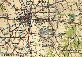
, showing trenches corrected to 13 July 1918 and the furthest advance of the German Army east of Ypres.")
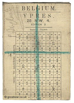
The map shown here is a section of a British Army Trench Map of the area east of Ypres on the Ypres Salient battlefields in Belgium. The scale is 1:10,000. The title of this map is Map Sheet 28 NW4. The date for trenches overprinted onto this map is given as “information received up to 13th July 1918”.
This map is of particular interest because it overprints the British trenches in red ink and the German trench lines in blue ink; this map was overprinted shortly after the British map makers had swapped the colours of blue and red from maps printed before early 1918 which had always shown the German enemy lines in red and the British line in blue. Another point of interest for this map is that it shows the German trenches extending as far west as Hellfire Corner on the Menin Road. This is the junction of roads seen in the centre of the map. After launching the Spring Offensive in March 1918 the Imperial German Army advanced westwards towards Ypres, crossing several miles of ground before they were halted within a couple of miles of the town. At this time of July 1918 the Allies were preparing to launch a major offensive against the German Army, which would push them eastwards again away from Ypres and which would eventually lead to the Allied Advance to Victory and the end of the war in November 1918.
British Army Trench Maps are an invaluable resource for researchers studying the First World War battlefields. They show the location of Front Lines, communication trenches, enemy positions, strongpoints and defences. They also show the names of farms, woods and villages which have become famous in themselves where they feature in the regimental histories, personal stories and War Diaries of the British Army in the battles on the Western Front.
This article explains why the British Army required the Trench Maps at this scale, how the map reference system was devised and how to find a location using a trench map reference.
- Development of the British Army Trench Map
- Map Sheet Reference Numbers
- Grid Reference Number for 1:10,000 Map
- Grid Reference: 24 Squares of 6,000 Yards (A - X)
- Grid Reference: 36 Squares of 1,000 Yards (1-36)
- Four Sub-sections of 500 Yards: a-d
- Co-ordinates within each 500 Yard Sub-section
- How to Find a Trench Map Reference
- Where to View WW1 Trench Maps
- Digitised Trench Maps & Reproductions
Development of the British Army Trench Map
 |
When the British Expeditionary Force (B.E.F.) went to war in France and Belgium it had to rely on the existing maps available to the General Staff in the August of 1914. Most of these maps were at a scale of 1:40,000 (for Belgium) or 1:80,000 (for France). Some were at an even smaller scale of 1:100,000 or 1:120,000. Maps at this scale were acceptable for senior commanders moving their forces against the enemy in what was a war of movement during the first few weeks of the war.
However, the fighting front gradually developed into a static situation of stalemate between the Allied Armies and the Imperial German Armies from the fighting in the Battle of the Aisne in September 1914. The war of movement turned into a war of attrition and a state of trench warfare existed on what became known as The Western Front by the turn of the year. This resulted in a new requirement to produce larger scale maps for use by the units located in this static situation on the ground. They needed larger scale maps of the area they were in to be able to pinpoint enemy defensive positions and accurately to build up a picture of the type of ground being held by the enemy. They needed to know its height, the location of buildings, woods, roads, railways, rivers and bodies of water. This would be vital not only for planning an attack on the enemy line but would also assist with the familiarization of strategic defensive locations behind the Allied Front Line. It was also necessary for the artillery to be able to range the guns accurately on identifiable, specific enemy targets such as enemy gun batteries and strongpoints.
Initially the British Ordnance Survey produced maps for the fighting front in France at 1:40,000 or 1:20,000 scale using enlargements of the French 1:80,000 maps they already had. Within a few weeks of the Battle of the Aisne the British Expeditionary Force (B.E.F.) had moved troops into the region of French Flanders north of Arras.
 |
By the end of October the B.E.F. was also fighting in Belgium east of Ypres. By the end of January 1915 it was decided to produce maps from a new survey of the ground on the British fighting front. From early in 1915 the Geographical Section of the General Staff, abbreviated to G.S.G.S., at the War Office began to produce Trench Maps for the fighting units at the Front. A small team of Royal Engineer observers and topographers from the 1st Ranging Section were gradually joined by trained surveyors from the Ordnance Survey in Southampton and other men of the Royal Engineers with map-making experience. The team grew into a much larger operation of field survey companies. By 1918 the map-makers were able to make corrections and print and distribute maps from the British rear areas.
Belgian National Survey Maps Rescued from Antwerp
With regard to the mapping of the Belgian fighting front, the commanders were able to use maps printed from original drawings and litho stone artwork rescued from Antwerp before the fall of the city to the Germans on 10th October 1914. The existing Belgian maps were considered to be accurate and of good quality so these could continue to be used to produce enlargements at 1:20,000 scale for the British Army fighting on the Allied Front near Ypres.
In addition to the good quality of the existing national survey work in the Belgian maps, there were good quality maps for the areas of northern, eastern and frontier regions of France where there were fortifications. These maps were at a scale of 1:20,000 and produced as Fortress Plans Directeurs. Accurate maps of the fortified cities of Calais and Lille could also be produced.
New Survey Work for the B.E.F. in France
|
New maps for the British Army in areas of France where they were holding the Front Line north of Arras during 1915 began to be produced at a scale of 1:20,000 from the new survey work.
1:10,000 Maps with Detail of Enemy Defences
The new larger scale Trench Maps were drawn at a scale of 1:10,000. These maps showed details of the enemy Front Line, machine gun posts, bunkers, communication trenches to the rear and any defensive positions behind the Front Line. From 1915 until early in 1918 the enemy (German) positions were shown in red. The British Front Line was shown in blue and generally only shown as a simple “approximate” line for the purposes of its location. Any maps which did show details of the British Front Line and supporting lines were classified as “Secret” and were not supposed to be taken beyond the Brigade Headquarters into the Front Line positions for fear they might be captured by the enemy in a trench raid or be discovered in the pocket of a dead officer during an attack.

The image is a section from British Army WW1 Trench Map Sheet 28 NW2 dated 13th May 1918. It shows the area north of Wieltje in the Ypres Salient. The blue overprinted markings are British and the red markings are the German trench lines and defences.
From early 1918 the over-printing on British Trench Maps swapped the blue and red colouring over and marked the enemy (German) positions in blue and the British positions in red (as in the map shown at the top of the page) in order to conform with the French system of trench mapping.
Details of the landscape, the enemy's positions and rear areas were regularly updated from photographs taken from the air by reconnaissance flights. Raids into enemy positions would lead to intelligence about the layout of positions. On both sides, maps did fall into the enemy's hands and often crucial information could be obtained from such captured maps and documents.
Editions, Corrections and Updating
The exact number of copies printed for each edition of the 1:10,000 Trench Maps does not exist as a record. According to Peter Chasseaud, a leading expert on military mapping in the First World War, a figure of between 6-8,000 copies of a map were printed for an edition produced in 1916, 1917 and 1918. Some maps in locations where there was continuous activity on the Front Lines or the planning and carrying out of major battles saw as many as 9 editions printed in the last two years of the war.
Some of the first 1:10,000 Trench Maps produced in 1915 from the 1:40,000 or smaller scale maps of France were revised during 1916 to remove inaccuracies and provide more accurate survey data.
The trench lines and enemy defences were updated more often on maps which were the locations of major battle operations. It was necessary to keep the maps up to date using intelligence and aerial observation to provide the attacking troops with the most accurate information about the enemy positions. The date of the overprinted trench lines and positions on a Trench Map can usually be attributed to the text at the top of the map which states: "Trenches Corrected to ...”.
Reference Key for a Trench Map
 for the Ypres Salient near Gheluvelt.")
The image shows a typical key for a Trench Map. This one is taken from Map 28 NE3 Edition 7B for the Ypres Salient near Gheluvelt. The key is shown here with the red text in the top left hand corner indicating the F.S.Co. (Field Survey Company) dating the trenches to 25th October 1917.
British Names for Map Locations
|
Many of the names of farms, woods, villages and so on which feature on the military Trench Maps for France and Belgium are in English.
One reason is that the French names were unusual and some were especially difficult for the British soldiers to pronounce when they arrived in France and Belgium. At the time of the 1914-1918 war the placenames of major cities and locations on the Belgian maps were in French. Smaller village names and other toponyms were in Flemish (Dutch), the language of the population in (West-)Flanders.
With the arrival of the British Expeditionary Force (B.E.F.) and the fact that the soldiers found themselves in a static trench warfare situation, it was inevitable that the British soldiers would soon familiarize the area they were in with placenames from “back home” or names related to their regiment. British soldiers are well-known for their sense of humour in situations of adversity, and in many cases a French name was changed and given a witty makeover as a nickname.
Perhaps the most famous of these transformations from French to English is the town name of Ypres. The British renamed it to “Wipers”. As the war developed into four years of fighting, that one word became synonymous for the British people and the veterans of Wipers with desperate fighting, great loss, courage and sacrifice. Another example of the witty transformation of a name was the village of Auchonvillers on the Somme battlefield in France; the British soldiers renamed it to “Ocean Villas”.
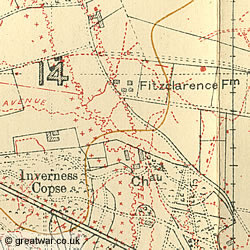
Names like “Dirty Bucket Corner” (northwest of Ypres) would likely have been given to this place by the troops. “Fitzclarence Farm” (east of Ypres) is an example of a farm named after a person. Brigadier General Charles Fitzclarence, VC, who commanded the 1st Guards Brigade from this location during the First Battle of Ypres in October and November 1914, was killed here on 12th November and his body was never found.(1) The men named the farm after him and it stayed that way on all the maps of the Ypres Salient.

In some cases the British map names were decided on by the map-makers. The letter of the map reference of the 6,000 yard squaring system influenced the naming of trenches and farms. For example, in grid square “I” on Map sheet 28 NW showing trenches corrected to 30th June 1917 an area near Verlorenhoek east of Ypres has a series of German trenches named on the British map with the letter “I”: Iberia Trench, Ibex Trench, Ibex Lane, Ice Trench, Ice Trench, among others.
Sometimes the British names on the maps originated from German names given to their own positions by the German soldiers. For the same reasons as the British renamed many of the placenames, the Germans also renamed farms, woods and villages after familiar homely places or their regiment. One example is the name of “Feste Staufen”, a large bunker (redoubt) on the Somme battlefield near Thiepval hamlet. The German 26th Reserve Division likely named it after the small town in the state of Württemberg where the division was recruited from. The British soldiers renamed it as “Stuff Redoubt”. A large farm on the Somme battlefield also near Thiepval was called “Mouquet Farm” in French. The Germans arrived there first in September 1914 and renamed it “Mücke Ferme” (Mücke translates as mosquito) on their maps and when the British arrived on the Somme battlefield in mid 1915 they transformed the French name of Mouquet Ferme into “Mucky Farm”.
Map Sheet Reference Numbers
 |
A map sheet reference number is built up from the following elements:
- 1:40,000 scale Map Sheet number
- 1:20,000 scale quarter section of 1:40,000 map (NW, NE, SW, SE)
- 1:10,000 scale sub-section number (1-4)
For example, a map sheet reference for the Ypres area in Belgium is:
- (1) Sheet 28 (2) NW (3) 4 = Sheet 28 NW4
Map Sheet Numbers for 1:40,000 Maps
It was decided to base the British Army Map Sheet numbering system on the existing numbering system of the Belgian map sheets. The 1:40,000 scale map sheets were, therefore, given a number. The map sheets covering the battlefield areas of the Western Front in Belgium were numbered as:
- Map 4: Belgian coast (northern section)
- Map 12: Belgian coast (southern section)
- Map 20: Dixmude area
- Map 28: Ypres area
- Map 36: Armentières-Lille area
The new map sheets for France, to the south of the Belgian border were initially assigned numbers following on from the Belgian sheet of Map 36 as 36A, 36B and 36C from west to east. The the maps to the south of these number 36 map sheets were referenced with C to A, D to A, E to A, or F to A from west to east. Towards the end of the war some of the map sheets were renumbered. The map sheets for France from north to south covering the Western Front, and the general area they covered, were numbered as follows:
- Map 36C: La Bassée-Loos area
- Map 51C: West of Arras
- Map 51B: Arras-Cantin
- Map 51A: Hordain area
- Map 57D: Hebuterne area
- Map 57C: Bapaume-Gonnelieu area (Battle of the Somme)
- Map 57B: Clary area
- Map 62D: Méaulte area
- Map 62C: Péronne area
- Map 62B: Ramicourt area
- Map 66E: Moreuil area
- Map 66D: Nésle area
- Map 66C: Berthenicourt area
- Map 70D St. Gobain area
Four Sections of Four 1:20,000 Map Sheets
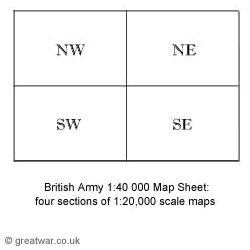
Each 1:40,000 map was divided into four sections. Each section was given an alphabetical reference of NW, NE, SW and SE. Printed copies of these map sections would be produced at a scale of 1:20,000.
Four Sub-Sections of Four 1:10,000 Map Sheets
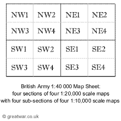
From mid 1915 the map-makers produced maps at a larger scale of 1:10,000. Each of the four NW, NE, SW or SE sections were further sub-divided into four sub-sections. These sub-sections were numbered as 1, 2, 3 and 4. This created a numbering system for a sub-section as follows:
- NW1, NW2, NW3, NW4
- NE1, NE2, NE3, NE4
- SW1, SW2, SW3, SW4
- SE1, SE2, SE3, SE4
The map sheet was also titled with the name of a major town or village. By way of example, the map reference for the map sheet covering the area and town of Ypres on the Ypres Salient battlefield is:
- Sheet 28 NW4 Ypres
Grid Reference Number for 1:10,000 Map
The grid reference for a Trench Map location was the same for the 1:20,000 scale and 1:10,000 scale maps.
A grid reference number is built up from the following elements:
- 1:40,000 Map Sheet number
- 6,000 yard square (A-X)
- 1,000 yard square (1-36)
- one of four 500 yard sections (a-d)
- 100 yard grid co-ordinates with eastings to northings (0-9)
For example, a grid reference for a location on the Map Sheet 28 NW4 (Ypres) would be given as:
- (1) Sheet 28. (2) I. (3).12. (4) b. (5) 5.9 = Map 28.I.12.b.5.9
Grid Reference: 24 Squares of 6,000 Yards (A - X)
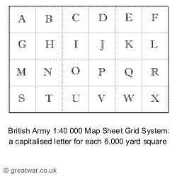
Working with the 1:40,000 scale maps, a squaring system for all the maps was established in measurements of yards and divided into 24 squares of 6,000 yards each. These squares were alphabetized in capital letters from A to X.
The British squaring system was in yards instead of metres as in the Belgian and French maps it was based on.
Grid Reference: 36 Squares of 1,000 Yards (1-36)
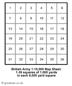
The 6,000 yard square was sub-divided into six squares of 1,000 yards each. Each 1,000 yard square was given a number from 1 to 36.
In some cases the 1,000 yard squares were limited to 30 instead of 36 according to the way the map sheets were
In some cases the 6,000 yard square at the western or eastern edge of the map actually contained only five 1,000 yard squares on the horizontal line. The reason for this is explained below.
Four Sub-sections of 500 Yards: a-d
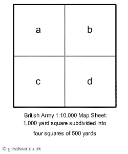
Each 1,000 yard square was divided into four sub-sections of 500 yards each. These sub-sections were given the letters (in lower case) of a, b, c and d.
Co-ordinates within each 500 Yard Sub-section
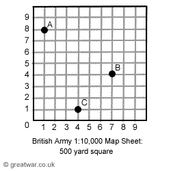
Within each of the a, b, c and d sub-section the square was marked with notches for each 50 yard marker. The co-ordinates' reference within a sub-section would normally be given as two numerical digits, such as 2.3. Within a 500 yard sub-section the first point would be located to the east and the second point to the north.
In the example of a 500 yard square shown here the references are:
- A: 1.8
- B: 7.4
- C: 4.1
How to Find a Trench Map Reference
|
If you are looking at War Diaries to find out the location of a unit on the battlefield and you find references to Trench Map co-ordinates, this is an example of how to find the Trench Map reference.
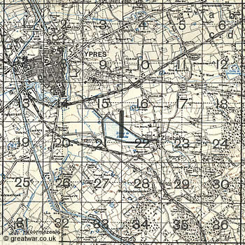
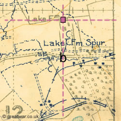
The section of Trench Map shown here shows Lake Farm to the east of Ypres, north of Bellewaerde Lake and the Menin Road (see square 12 on the Trench Map at the top of this page).
The Trench Map reference for Lake Farm is:
- Map 28.I.12.b.5.9
- On Map Sheet 28 the 6,000 yard square is “I” = 28.I
- The 1,000 yard square within “I” is square number 12 = 28.I.12
- The 500 yard quarter sub-section square is “b” = 28.I.12.b
- Using the 50 yard “notches” marked on the top and right side of the “b” square, Lake Farm lies on the co-ordinates 250 yards east at 5, and 450 yards north at 9 = 28.I.12.b.5.9
Lake Farm was likely named because of its close proximity to the Bellewaerde Lake. Lake Farm Spur can be seen as a spur off a narrow-gauge field railway line running to the farm.
Where to View WW1 Trench Maps
Finding a British Army WW1 Trench Map for a bargain price in a second hand bookshop is a very rare thing nowadays. Trench Maps are sought after by collectors and those with handwritten text on them can fetch high prices if they are up for sale. It is possible, however, to see Trench Maps at two of the leading archive locations for First World War maps, where a large selection of Trench Maps are available to be viewed by the public:
Imperial War Museum
See our page about visiting the collections at the museum and links for searching online.
National Archives, Kew
Search the National Archives' Catalogue for trench maps in the Maps and Plans War Office (WO series) collection starting from catalogue reference WO 153/1. Some War Diaries held in the National Archives also contain Trench Maps as an appendix to the Diary. Go to the National Archives website for details of the map collection:
Website: www.nationalarchives.gov.uk Military and Overseas Maps
Digitised Trench Maps & Reproductions
Reproductions of Trench Maps and the opportunities to study them on a computer have become more widely available thanks to the advance in digital technology to scan and produce them on CD Rom or DVD. A number of collections now available to buy are listed here, together with books by Peter Chasseaud, the leading expert on the subject.
British Trench Map Facsimile Reproductions
Facsimilie reproductions of selected British Army trench maps in the Belgian and French sector on the Western Front and the Greek sector in Salonika/Macedonia. These maps can be purchased from the publisher at a very reasonable cost from G H Smith & SonL
Website: www.ghsmithbookshop.com World War I Trench Maps
Imperial War Museum Trench Map Archive on CD Rom
Published by Naval & Military Press. (175 large-scale maps). Currently unavailable to purchase.
LinesMan
The Great War Western Front GPS companion. 750+ geo-referenced British trench maps of the Great War for France & Belgium in 1:10,000 scale. 2 box DVD set published by Great War Digital Ltd. Available to buy online:
Website: www.greatwardigital.com LinesMan
McMaster University Digital Archive
A large online collection of WW1 trench maps and aerial photos, with excellent information on how to interpret the maps, how to read a trench map reference, how to read an aerial photo reference, glossary terms, map symbols, and more. Theatres of war include France and Belgium, Gallipoli, Middle East, Africa, East Africa, Egypt, Italy, Russia and the Balkans.
Website: library.mcmaster.ca Maps/WW1
Mapping the Front
The Western Front Association in association with the Imperial War Museum London have produced a series of DVDs of trench maps and aerial photographs. For details see “Mapping the Front” on The Western Front Association website.
Website: www.westernfrontassociation.com Mapping the Front
National Archives British Trench Map Atlas
1:10,000 regular series with an index of over 20,000 trench and topographical names and a commentary for each map. Published by Naval & Military Press (700+ maps). Available to buy online:
Website: www.naval-military-press.com National Archives British Trench Map Atlas
National Archives Captured German Trench & Operations Maps
CD Rom, published by Naval & Military Press. (192 large-scale maps)
Website: www.naval-military-press.com National Archives Captured German Trench & Operations Maps
National Library of Scotland (NLS)
British First World War Trench Maps, 1915-1918
Website: maps.nls.uk
Topography of Armageddon: A British Trench Map Atlas of the Western Front
By Peter Chasseaud, FRGS. 190 full-page photographically reproduced trench maps (black & white) from the author's collection. ISBN 9781843422006. Available to buy online from Naval & Military Press:
Website: www.naval-military-press.com Topography of Armageddon: A British Trench Map Atlas of the Western Front
Further Reading
Trench Maps - A Collector's Guide by Peter Chasseaud FRGS, Mapbooks, 1986, ISBN 0-9512080-0-4 (out of print)
Artillery's Astrologers - A History of British Survey and Mapping on the Western Front, by Peter Chasseaud, FRGS, Mapbooks 1999, ISBN 1843421992

Mapping the First World War: The Great War through maps from 1914-1918 (Imperial War Museum) (Hardcover)
by Peter Chasseaud and Imperial War Museum
Published by Collins (24 Oct 2013), 304 pages; ISBN-10: 0007522207; ISBN-13: 978-0007522200
WW1 Maps on CD Rom/DVD

Military Operations Other Theatres: 1914-1918 Maps (CD Rom)
Published by Naval & Military Press Ltd (10 Sep 2001); ISBN-10: 1843423871; ISBN-13: 978-1843423874

Captured German Trench and Operations Maps from the Public Record Office Archive (CD)
by Peter Chasseaud
Published by Naval & Military Press Ltd (4 May 2005); ISBN-10: 1843425157; ISBN-13: 978-1843425151. (Not compatible with Windows Vista or Windows 7)

National Archives British Trench Map Atlas. The Western Front 1914-18. 1:10,000 Regular series with an index of over 20,000 Trench and Topographical names and a commentary for each map (DVD)
Edited by Peter Chasseaud
Over 700 maps. Includes an index to trench names and places of interest and a commentary by Peter Chasseaud, a world-renowned expert in military cartography. Published by Naval & Military Press Ltd (2 Jun 2008); ISBN-10: 1847348661; ISBN-13: 978-1847348661
Related Topics
WW1 Research and Sources of Information
WW1 Research and Sources of Information
Footnote
(1) Brigadier General Fitzclarence, VC is the highest ranking officer named on the Menin Gate Memorial to the Missing in Ypres.
Menin Gate Memorial: Brigadier General Fitzclarence
Acknowledgements
Trench Maps - A Collector's Guide by Peter Chasseaud FRGS, Mapbooks, 1986, ISBN 0-9512080-0-4 (out of print)
Jos Demaree