 Summary of the Battle of Gravenstafel Ridge: 22nd April, 5pm to midnight
22 April 1915: 17.00 - 24.00
After three attempts to blow the gas cloud across the sector held by two French divisions in the northern part of the Ypres Salient, the German infantry attack on the sunny spring afternoon of 22nd April made significant advances into Allied held territory.
Most of the French territorial and Algerian troops not immediately asphyxiated by the poisonous gas retired from the front line in confusion. The German infantry, following on behind the gas cloud at 5.15pm, successfully broke through the Allied front line.
Within half an hour of the attack the German 52. Reserve Division in the centre of the attacking front had covered 3 to 4 kilometres of French-held ground and had reached its first objective - the high ground of Pilckem Ridge - by the village of Pilckem.
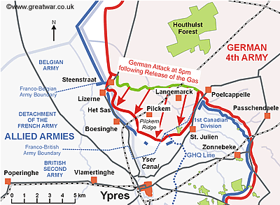
The German 45. and 46. Reserve Divisions reached the Yser Canal and established bridgeheads on the west bank at Steenstraat and the lock at Het Sas (south of Lizerne). A dangerous gap in the Allied front line was created as a result of the French withdrawal. The way to Ypres was open.
The left wing of the British Second Army sector (at St. Julien) was not directly attacked. However, as a result of the French withdrawing on their immediate left, the rear of 13th Battalion of 1st Canadian Division was in danger of being exposed. This battalion, together with some French troops, formed a flank on the left wing of the British sector along the St. Julien-Poelcappelle road. They put up a stubborn defence to hinder the progress of the German 51. Reserve Division on the left wing of the German attack.
A French counter-attack was launched at 8pm from Boesinghe towards Pilckem but it made little progress. A counter-attack was prepared by the Canadian 3rd Infantry Brigade for 11.30pm. Its launch was postponed until midnight and the attack took place in the early hours of the morning of 23rd April.
By midnight on 22nd April the Allies had lost a significant amount of ground in the north part of the Ypres Salient. At about 8.30pm the German infantry stopped its advance and held an advantageous position on the high ground of Pilckem Ridge. German artillery then subjected Ypres and its surrounding area to a heavy artillery bombardment during the late evening. The intention was to hinder the Allies in their attempt to bring reinforcements into the area overnight.
Naming the Battle

The Battles Nomenclature Committee gave the name of the Battle of Gravenstafel Ridge to the first battle of The Second Battle of Ypres fought from 22nd to 23rd April. The British Official History comments that there does not seem to be a reason for connecting this first battle with the Gravenstafel Ridge. The ridge was an east-west spur, on which the village of Gravenstafel was situated, running off the high ground of the ridge to the east of Zonnebeke. The German attack and the British counter-attacks actually took place farther to the west in the region of Keerselaere and west of St. Julien.
Contents Page for Battle of Gravenstafel Ridge: Phase One Section
For a list of all the pages in the sequence of events by time go to:
Contents Page for Battle of Gravenstafel Ridge: Phase One Section
Battle of Gravenstafel Ridge: Phase One Section
For the story of what happened when the gas began to drift towards the French trenches, start the Battle of Gravenstafel Ridge: Phase One sequence of pages:
References
The main sources of reference used for the Battle Study are listed here. Each source of reference is linked to the fuller details of the books and documents provided in the Bibliography list at:
A Crown of Life: The World of John McCrae
British Military Operations: France & Belgium 1915
Die Schlachten und Gefechte des Grossen Krieges 1914-1918
Gas! The Battle for Ypres, 1915
Geschichte des Reserve-Infanterie-Regiments Nr. 210
Geschichte des Reserve-Infanterie-Regiments Nr. 238
Histories of Two Hundred and Fifty-One Divisions
Königlich Preussisches Reserve-Infanterie-Regiment 213
Les Armées Françaises dans la Grande Guerre
Official History of the Canadian Forces in The Great War 1914-1919
War Diary of 1st Canadian Division
War Diary of the 3rd Canadian Infantry Brigade
War Diary of the 10th Canadian Battalion