Battle Remains on the Somme Battlefields, France

Battle remains are listed here which are accessible to the public or easy to see for visitors to the 1914-1918 Somme battlefields.
-
Butte de Warlencourt, Le Sars
50.07581492007727
2.7948778867721558
East side of the D929 Le Sars - Bapaume road
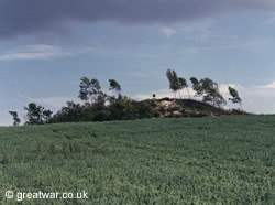
The Butte de Warlencourt is an artificial hill. It was used as a location of strategic high ground in the Franco-Prussian war of 1870-1871 and again in the Battles of the Somme in 1916 and 1918.
The Butte was full of tunnels even before the Germans fortified it in the First World War. The Butte was taken by the British when the German Army retreated to the Hindenburg Line (called the Siegfriedstellung in German) in February 1917. The hill was retaken during the German offensive in March 1918. The British 21st Division captured the Butte on 25 August 1918 during the Allied Advance to Victory.
The Butte has been owned by The Western Front Association since 1990. There is a memorial plaque on the summit.
-
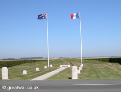
Cratered Ground, Delville Wood, Longueval
Longueval
50.0287336898161
2.810772657394409
Delville Wood (Bois Delville), also known as Devils Wood by the British Army, was almost completely destroyed during the fighting here from mid July 1916 during the Battle of the Somme 1916.
Cratered Ground: Delville Wood
By the end of the battle in November 1916 the wood and its surrounding area looked like a moonscape, with stumps of tree remains and cratered ground. This wood has been regrown in its original shape and is preserved as a memorial to the men who fought and died here. Most particularly the battalions of the South African Brigade are remembered at this place and it is the site of the South African Forces' National Memorial and Museum.
-
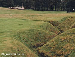
Glory Hole, La Boisselle
La Boisselle
50.018651121995084
2.690325379371643
An area of ground near to Lochnagar Crater, named “The Glory Hole” on British Army maps. It was the area of the first offensive mining carried on this part of the Western Front between the French and German Armies at the turn of the year 1914/1915.
The cratered ground has been left as it was after the war. It is on private land and not accessible to the public, but the undulating ground can be seen from the bank next to the road.
A project officially launched in June 2011 hopes to make an archeological and historical study of this ground, with the intention to provide access for visitors at some date in the future.
-
Hawthorne Ridge Mine Crater
Beaumont Hamel
50.083222208004365
2.6502424478530884
Trees on the ridge mark the location of the lip of the Hawthorn Crater near Beaumont Hamel.
The mine under the German Front Line position at Hawthorn Redoubt was detonated at 07.20 hours on 1st July. It was one of three huge mines and several smaller mines blown on this day at the launch of the British infantry attack in the Battle of the Somme. It was the only mine exploded on the northern (left) wing of the attack front.
The huge crater formed by the explosion still forms a large hole in the landscape. However, unlike the remains of the the crater a few miles further south at Lochnagar Crater, the undergrowth has grown up around the lip of the crater. Unless there is a sign barring access to unauthorized persons, it should be possible to get to the crater by walking up the narrow track from the road leading into the north-west end of Beaumont-Hamel. Due to dense undergrowth it is only advisable to do this if the path is relatively clear and care is taken, especially when travelling alone.
-
Last Tree, Delville Wood, Longueval
Longueval
50.02763068890777
2.8116872906684875
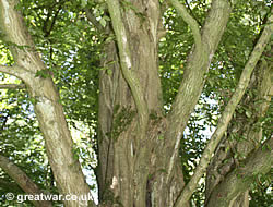
The “Last Tree” is the only surviving hornbeam tree of the wood known as Delville Wood or Devils Wood during the 1914-1918 war. The wood now forms the grounds of the Memorial to the South African Forces.
The wood was smashed to bits during the battle for the wood when the German artillery pounded the South African Brigade attack starting on 15th July 1916. The tree has grown since the war and its trunk is studded with metal shell splinters.
-
Lochnagar Crater, La Boisselle
La Boisselle
50.01550749783013
2.6974064111709595
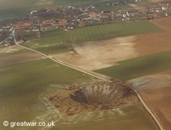
The huge crater was created by the detonation of a mine under the German position at 07.28 hours on 1st July 1916.
-
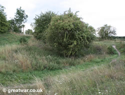
“The Danger Tree” (Petrified Tree), Newfoundland Memorial Park, near Hamel
Newfoundland Memorial Park near Beaumont-Hamel
50.07489914227695
2.649853527545929
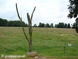
A petrified tree, known as “The Danger Tree”, is the only known original tree on this part of the Somme battlefield north of the Albert-Bapaume road to survive the 1914-1918 fighting.
Danger Tree: Newfoundland Memorial ParkAccording to accounts by First World War veterans who fought in this sector, the tree was the only vertical landmark in an otherwise cratered landscape in No Mans Land approximately halfway between the British and German Front Lines. When soldiers were out on patrol to the German lines at night, veterans have said that they used the location of the tree to guide them back in the direction of their own line. The Germans knew they did this and would range their guns on the tree, making this a very dangerous place to be!
-
Preserved Trench at “Ocean Villas”, Auchonvillers
Auchonvillers
50.079919
2.630576
Original section of trench which has been preserved, is maintained by volunteers and can be visited.
Trench at “Ocean Villas” (Auchonvillers) -
Preserved Trenches, Newfoundland Park Memorial, near Hamel
Newfoundland Memorial Park near Beaumont-Hamel
50.07485094296086
2.648549973964691
After the First World War Newfoundland purchased a piece of land between the villages of Auchonvillers, Beaumont-Hamel and Hamel. This was the location where the battalion of the Royal Newfoundland Regiment went into action on 1st July 1916. At the time the Royal Newfoundland Regiment was fighting with the British Army and not with the Canadian forces.
Newfoundland Memorial ParkIn addition to the planting of fir trees and the setting aside of this site as a memorial, the original location of the British front line trench and reserve trenches from July 1916 were simply left. More recently the Canadian government has taken action to ensure the preservation of these trenches owing to the increasing number of visitors wanting to walk in and on these old trench lines. As a result, visitors are restricted to pathways around the trenches.
The preserved trenches are located in the Newfoundland Memorial Park between Auchonvillers and Hamel.
-
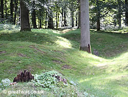
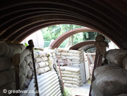
Preserved Trenches, Thiepval Wood (Bois d'Authuille)
Route de St.Pierre Divion, 80300 Thiepval, France
50.058242
2.680211
Thiepval Wood was purchased by the Somme Association in 2004. The Somme Association cares for The Ulster Tower, a memorial to the 36th (Ulster) Division. The wood is located to the south-west of the Ulster Tower. It is the place from which the men of the 36th (Ulster) Division made their attack on 1 July 1916 towards the German lines between St. Pierre Divion and Thiepval village.
An archaeological project has been carried out since 2004 to preserve and examine the wood. Sections of original trenches have been restored and paths have been made. Tours of the wood and preserved trenches can be made by appointment with the Somme Association. Tours are available March-November Tuesday to Sunday 11.00 or 15.00 hours. Please note: Thiepval Wood is private property and anyone entering the wood without permission from the Somme Association will be trespassing.
To make an appointment for a tour:
Telephone: +33 3 22 74 87 14
Email: ulstertower@sommeassociation.com
Email: sommeassociation@btconnect.com
Website: www.sommeassociation.com Contact
-
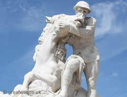
Pozières Windmill
Pozières
50.04510272711799
2.735893428325653
Site of the windmill at this location, used by the artillery observation officers of the German XIV Reserve Corps when they first occupied this part of the Somme battlefield in late September 1914.
Australian Memorial, Pozières Windmill
The windmill was eventually destroyed by June 1916 before the launch of the Allied offensive, but the remains of the foundations have been left and grass has grown over the site.
The site of the windmill is now an Australian memorial. Visitors are advised to take great care when moving to and from parked cars as this is a very fast main road. Children should be supervised at all times.
-
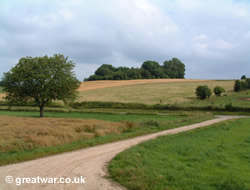
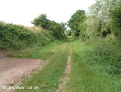
Scars on the Landscape: Trench Line at Thiepval
Thiepval
50.0568283485393
2.6863503456115723
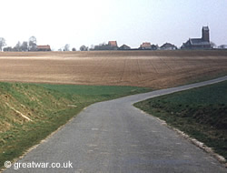
A trench line near to the hamlet of Thiepval can usually be seen during the winter months.
Visitors to the battlefields at certain times of the year, in the autumn, winter and spring when the fields are ploughed, will see scars on the landscape of the Somme. Chalky lines can often be seen criss-crossing the fields where trench lines were dug or large shell craters were blown below the topsoil.
-
Sheffield Memorial Park Cratered Ground
Serre
50.106373960472624
2.656599283218384
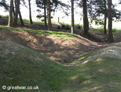
Cratered ground preserved as a memorial park to the Pals Battalions who fought west of Serre village in the Battle of the Somme 1916.
Sheffield Memorial ParkThe cratered ground at Sheffield Memorial has been preserved as a memorial to the men of the British Pals Battalions who fought on 1 July 1916 in the sector west of Serre village. Hundreds were cut down, wounded or killed.
-
The Sunken Lane, Beaumont Hamel
Beaumont Hamel
50.08602408417658
2.6485365629196167
The Sunken Lane was a lane running in a north-south direction and situated in No Mans Land, roughly halfway between the opposing Front Lines west of Beaumont Hamel village until the fighting moved beyond the village in November 1916. From September 1914 the French Army occupied the Allied Front Line here. From August 1915 the British Army took over the Front Line sector here.
Before the launch of the Allied offensive on 1 July 1916 the area was busy with patrolling parties going out at night from the British and German lines. According to the German regimental histories, whichever side took control of the Sunken Lane during a night-time patrol, would be in the best position to dominate No Mans Land for the remainder of the patrol.
The Sunken Lane featured in the attack by the 1st Battalion Lancashire Fusiliers on 1st July 1916. The attack by this battalion was led by two of its companies, which had gone forward of the British Front Line via a sap into the Sunken Lane. The battalions other two companies were in the British Front Line to the west of the Sunken Lane. All four companies left their positions at Zero Hour 07.30 hours on 1 July, but were cut down by a German artillery barrage onto the British Front Line trenches and by German machine gun fire from the north-west corner of Beaumont-Hamel village. Very few Lancashire Fusiliers got beyond the Sunken Lane and casualties in the battalion were over 480 by the end of the day, including over 160 killed.
The Sunken Lane can be accessed from the road (D163) leading into the west part of Beaumont-Hamel village.
Related Topic
|
See our page listing monuments and memorials to be visited in memory of those who fought on the Somme battlefields: