Spanbroekmolen Mine Crater Memorial — The Pool of Peace, Belgium

|
The Spanbroekmolen Mine Crater, also known as Lone Tree Crater, is the site of the largest of 19 mines blown by the British Army in the early hours of the morning of 7 June 1917. This signalled the launch of the Battle of Messines.
Site of the Spanbroekmolen Windmill
|
In 1914 Spanbroekmolen was the site of a windmill (“molen” is the Dutch word for “mill”). At the end of the First Battle of Ypres in November 1914 the German Front Line was established in this location on the high ground of the Messines Ridge. Between then and 7 June 1917 the Germans spent a year and a half developing well-established positions here with concrete bunkers and strong defensive positions.
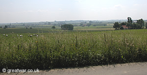
Most importantly, the position had very good views across the lower lying British positions. The photograph looks across the area of the British lines in a south-westerly direction from Spanbroekmolen. The British Front Line ran from left to right in the field a few metres beyond the road. The church in the middle distance on the far left of the picture is in Wulverghem village. The German position is immediately behind the camera on the high ground of the ridge. Being high on the ridge the Germans were also preventing the British Army from seeing into the German rear areas.
British Army Trench Map 28 S.W.
 with trenches corrected to 28.12.16 (scale 1:20,000)")
British Army trench map 28 S.W. (Edition 4) scale 1:20,000 shows the location of the German Front Line trenches in red, corrected to 28 December 1916. The British Front Line is marked in blue. It was deliberately not marked in detail in case the map fell into German hands. The yellow pencilled colouring on the map was done at the time to highlight the ground between the 50 and 60 metre contours. The grey pencil marking on the area of Spanbroekmolen in the centre of the map was done in 1917 to highlight the 75 metre contour. The mapping symbol for the original windmill (a circle with a cross on the top) is marked to the left of the capital "S" of Spanbroekmolen.
The Spanbroekmolen Mine
The mine at Spanbroekmoelen was started by 171st Tunneling Company, Royal Engineers, on 1st January. Six months later the mine was finished. To celebrate the mine's completion two officers made their way into the chamber with four bottles of champagne and drinking glasses. The main charge for the mine was made up of 50 LB (pound) boxes of ammonol, totalling 90,000 lbs (pounds). The main charge was finally completed on 28 June 1916 and officially completed, according to the War Diary, on 1 July 1916. (1)
A branch gallery had also been driven in the direction of Rag Point, which was a German position about three quarters of a mile south of the Spanbroekmolen position. In February 1917 the Germans dug a tunnel underneath the British gallery. They set explosive charges to explode two camouflets. As a result the right hand branch of the British gallery was damaged and it was abandoned.
On 3 March 1917 the Germans blew another camouflet which damaged about 900 feet of the main gallery. It broke the connection for the electric detonator leads for the explosive charge which had been lying silently in position under the Spanbroekmolen position since June the previous year.
A new gallery had to be mined to by-pass the damaged tunnel and the detonator leads had to be rerouted through this new tunnel to the chamber and explosives. There was serious difficulty with gas while the new tunnel was being dug. The mine was to be ready to blow at the launch of the major attack on the German lines on the Messines Ridge in June.
In a race against time the new by-pass gallery was completed and tamped. The detonating charge, consisting of 500 lbs (pounds) of ammonal and 500 lbs (pounds) of dynamite was laid on 1 June. The mine was to be fired by power and alternative firing by exploders was arranged in case the electric circuits did not function. The mine was finally completed on the night of 6 June 1917. Major Hudspeth, commander of the 171st Tunnelling Company, sent a message to the headquarters of the 36th (Ulster) Division that night. This division was to attack the German position at Spanbroekmolen at the start of the British attack set for 03.10 hours the following morning, 7 June. Major Hudspeth's message confirmed that it was “almost certain” that the mine would blow the next morning. The commanders of the 36th (Ulster) Division could only wait in anticipation to see if it did.
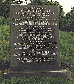
The dimensions and details of the Spanbroekmolen mine are as follows:
- depth of charge: 88 feet (26 metres)
- diameter at ground level: 250 feet (76 metres)
- width of the rim: 90 feet (27 metres)
- depth below ground level: 40 feet (12 metres)
- height of rim: 13 feet (4 metres)
- diameter of complete obliteration: 430 feet (131 metres)
- length of gallery: 1,710 feet (521 metres)
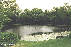
The crater has filled with water as a result of the high water table and the clay soil in the area.
Toc H and “The Pool of Peace”
|
The mine crater was purchased for Toc H by Lord Wakefield in the 1920s to be preserved as a memorial site on the Ypres Salient battlefields. The mine crater has subsequently been named the “Pool of Peace” and is still the property of Toc H in Poperinge.
The information stone in the photograph is located next to the entrance gate.
To find out more about Toc H (Talbot House), Poperinge, see our page at:
Toc H (Talbot House) Poperinge
Location of Spanbroekmolen Mine Crater
Leave Ypres on the Rijselsstraat via its southern exit through the Lille Gate and over the moat. At the roundabout go straight on into the N336 Rijselsteenweg making for the village of Wijtschate. After about 3.5 kilometres you enter the village of St. Elooi. When you arrive at a roundabout take the second exit N365 Armentiersweg to Wijtschate.
After 2 kilometres take a right hand turn into Wijtschate village on the Hospicestraat. This will take you into the village square. Make your way around the square to the far north-west corner and take the (5th) exit Wijtschatestraat following the sign for Kemmel.
After 1.4 kms take the second turning on the left into Kruisstraat. Spanbroekmolen memorial site is approximately 200 metres on the left. Just past the crater site there is room to pull off the road on the left to park, but it is not a designated car park.
Access to Spanbroekmolen Mine Crater

|
This is a site open to the public at all times. There is a natural path around the rim of the crater but visitors are advised that access may be restricted by undergrowth. Great care should be taken if walking close to the water.
Related Topics
|
Battles of the Ypres Salient
To find out more about the battles which took place in the Ypres Salient see our page at:
Cemeteries and Monuments in the Ypres Salient
Cemeteries in the Ypres Salient
Monuments & Memorials in the Ypres Salient
Acknowledgements
(1) War Diary of 171st Company Royal Engineers, Source: National Archives, Kew, Reference WO 158/51
Website: www.nationalarchives.gov.uk