A History of Ypres (Ieper): Origins

- Origin of the Name Ieper
- Hub of Trade Routes
- Centre of the Wool and Cloth Trade
- Iepere River Canalised
Origin of the Name Ieper
The earliest record of the name of Ieper dates from 1066. At that time it was a settlement of two parts to the east of a small river. One part of the settlement was on a higher piece of ground with dwellings for people and farming. The other piece of land was between the the higher piece of ground and the river. It was low-lying and marshy and was essentially used for grazing animals. This original settlement of Ieper was located in the place near the Grote Markt (Grande Place) or market place and the St Martin's Cathedral are situated in the centre of the modern town.
The name Ieper derives from the name of a stream, which flowed from its source on the slopes of the Kemmelberg in a north-easterly direction towards the early settlement that gradually developed into today's city of Ieper. The Kemmelberg is one of a series of hills forming a high ridge to the south of the city. There was an Iron Age Celtic Fort on the Kemmelberg.
Along this small river there were numerous elm trees growing. The elm was a common native species in the region. It was called an “Iep” in the language of the Belgae people, considered to be derived from the Germanic Frisian language. The river was known as the “Ipre” or “Iepere” after the elms that grew along it and the settlement on this river was subsequently named Ieper.
The Roman invasion of the region in the first century B.C. resulted in their naming the town in its Latin derivation of Ypra. Cartographic representations of Ieper over the centuries vary in the ways that Ieper is spelt, including Ipre, Ipres, Iprae, Ipera, Iperen, Hypra, Hipra, and Ipretum and Ipresnsis.
In later times, French forces captured and took over the town more than once, and also the town was officially French-speaking as the official language of the new Belgian nation was French from 1830, the town was known by its French name of Ypres, again derived from its original name of Ieper.
River Iepere Adapted
In the 10th century the Iepere river was flowing from the Kemmelberg, via Ieper, Dixmuide, Ostende to Brugge and into the sea. However, from the 11th century the Iepere river flowing through Ieper was re-routed by the local people as part of defensive measures and to assist small trading boats to navigate into the centre of the town.
Diversions were put in the river to create two moated areas of high ground in the south and in the north of the town. There was also an additional diversion created from the southern moated sectors so that the river flowed from there through the centre of the town along an artificially channeled second parallel arm to join the northern moated sector. The word “leet” in the local Flemish language means“adapted”, and as a result of the adaptations to the flow of the river at this time the river name of Iepere acquired the suffix of “leet”, becoming known as the “Ieperleet”. Later the “t” was dropped from the end of the name, and the river nowadays is known as the Ieperlee.
In the 14th century and the Burgundian period of occupation, one of the man-made adaptions to the river and its flow through the town as the adapted Ieperleet, was that a sluice gate was constructed under one of the round towers in the Rijselpoort (Lille Gate). This was to control the waterflow from the river into the town.
Hub of Trade Routes
Since the first century B.C., when the Belgae people were conquered by the Romans under Julius Caesar in about 54 B.C., the Flanders region had been invaded by successive armies and has suffered from the ravages of war. In spite of this, Ypres managed to establish itself as a financially and culturally rich city in the 12th century. By the 13th century Ypres had gained the status of an independent city-state.
Being only 40 miles inland from the Belgian coast, Ypres was the hub of many important trade routes consisting of roads, rivers and canals leading to the Netherlands, France, the English Channel and England.
Centre of the Wool and Cloth Trade
|
In the middle ages Ieper grew into an important market place for the region. Easy access to the coast meant that the the people of the city established links with the wool trade in England. The city became a very important centre for the cloth trade. Guilds and master guilds were founded.
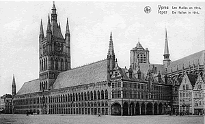
The Lakenhalle (Cloth Hall) was begun in the centre of Ypres in 1200. It took 100 years to complete. In 1241 there was a fire in the city which destroyed many of the wooden buildings. By 1260 the population of the city had grown to 40,000.
Medieval Wealth
Ypres grew into a wealthy and powerful city. In medieval times it was the third largest city in the County of Flanders after Gent and Bruges. The County of Flanders (Graafschap Vlaanderen in Dutch, Comté de Flandre in French) was first created as a fief of the Kingdom of France from 862. It existed as a County under various ruling houses until the French monarchy was removed from power in 1795 by the French revolutionaries. At its peak of economic prosperity the County of Flanders was one of the wealthiest regions in the whole of Europe.
Iepere River Canalized
|
To the north of Ieper the river called Iepere (and Ieperleet) flowed into the Ijzer (Yser) river at Drie Grachten. The Ijzer (Yser) river is the shortest of the three Belgian rivers (the Ijzer, the Maas and the Schelde) which flow into the sea and the only one of those three which flows into the sea on the Belgian coast.
Driven by the tremendous growth in the Ieper lace and cloth trade, the need for larger boats to be able to reach the centre of Ieper resulted in the digging of a canal to join with the River Ijzer (Yser) and so connect Ieper with the coast at Nieuwpoort via Diksmuiden. From Drie Grachten the Ieper-Ijzer (Ypres-Yser) canal was dug as far as a quay in the north of Ieper town. Thousands of boats and barges used the canal to ferry goods to and from Ypres to the coast.
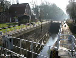
The sluice gate at Het Sas near Boezinge dates from the late middle ages. The word “Sas” in Flemish means “sluice”. The brewery “Het Sas” in Boezinge, near the Het Sas lock, is believed to be the oldest known brewery in Belgium.
|
The flow of water into the town enabled small barges and boats to travel from the Ieper-Ijser (Ypres-Yser) canal as far as the centre of the town. Until 1686 boats from the Iper-Ijser canal could connect with the Ieperleet river and travel into the town. Boats could make their way along the canalised Ieperleet from the main canal through what is now the Veemarkt. From here they could either take a section of river through the square that is now Vandenpeerboomplein past the west door of St. Martin's Cathdral and as far as a set of steps for unloading goods into the western end of the Cloth Hall warehouses. Or they could make their way to the fish market (Visserskai - Vismarkt) along a second arm of the Ieperleet river.
Acknowledgements
(1) Postcard of the Cloth Hall (Lakenhalle) as it was in 1914 from a set printed in 1930 by Ern. Thill, Bruxelles.
Vesting Ieper, Wandeling in een historisch landschaap, Lieven Stubbe, Dominiek Dendooven, Johan Termote, Philippe Vanderghote
The Reconstruction of Ieper: A Walk Through History, by Dominiek Dendooven and Jan Dewilde
Ieper La Carte - de Ieperse Vestinginen in Kaart Gebracht, von Ann Vanrolleghem
Ypres and The Battles of Ypres Illustrated Michelin Guides to the Battlefields (1914-1918)
nl.wikipedia.org/wiki/Ieperlee
http://www.erfgoedforumbrugge.be/Waggelwater%20spoorwegbrug.html


