Tyne Cot Cemetery, Zonnebeke, Ypres Salient Battlefields, Belgium

|
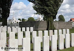
Tyne Cot Cemetery is the resting place of 11,954 soldiers of the Commonwealth Forces. This is the largest number of burials contained in any Commonwealth cemetery of either the First or Second World War. It is the largest Commonwealth military cemetery in the world.
The dates of death of the soldiers buried at Tyne Cot cemetery cover a period of four years, from October 1914 to September 1918 inclusive.
- The Origins of Tyne Cot Cemetery
- Origin of the Name of “Tyne Cot”
- German Concrete Defensive Line at Tyne Cot
- Tyne Cot Cemetery after 1918
- 8,367 Unidentified Burials
- Tyne Cot Memorial to the Missing
- Victoria Cross Winners Buried in Tyne Cot Cemetery
- Register of Names in Tyne Cot Cemetery
- Plan of Tyne Cot Cemetery
- Visitors' Centre and Parking at Tyne Cot
- Location of Tyne Cot Cemetery
The Origins of Tyne Cot Cemetery
|
Tyne Cot cemetery first came into being in October 1917 when the ridge where the cemetery is now located was captured by the British Army. One of several German blockhouses was large enough to be used as an Advanced Dressing Station. As a result of casualties not surviving their wounds in this medical Dressing Station there were 354 burials near the Dressing Station.
Most of the graves in the vicinity of the Cross of Sacrifice will, therefore, be identified as they died of wounds in this place and were subsequently buried here. The graves of these burials are for soldiers, including some Germans, who died between 6 October 1917 and the end of March 1918 when the German Army attacked and retook this ridge of high ground south of Passchendaele village.
The cemetery was then again in German occupied ground from 13 April until 28 September 1918, when the Belgian Army captured the ridge in the final push during the last weeks of the war.
Origin of the Name of “Tyne Cot”
|
A building named “Tyne Cott” or “Tyne Cot” on British Army trench maps was located near the north-west corner of a large German military cemetery on the reverse slope of the ridge. The German cemetery no longer exists as the graves were removed after the First World War and re-interred in formal German military cemeteries. The graves would have likely been moved to Langemarck German Military Cemetery, which is a only few miles away.
There is a suggestion that the name of Tyne Cott (or Tyne Cot as it is sometimes printed on trench maps) was given to a small farm building near the level crossing of the Passchendaele-Broodseinde road by the Northumberland Fusiliers. It is said that because the assorted buildings and German bunkers on the horizon gave an appearance of Tyneside cottages from the British position in the valley.
|
It is more likely that the name was given to the farm building by the British Army map makers as one of a series of buildings named after several large European rivers. In the vicinity of Tyne Cot there are several other farms and buildings marked on the British Army trench maps with the names of Seine, Thames, Marne, Rhine and Tiber. Tyne would likely have been another large river in this sequence of river names.
The word “Cott” is also sometimes alternatively marked as “Cot” on British Army trench maps. The origins of why the British started naming some buildings on their maps as “Cott” is interesting as it may stem from the shortened form of “cottage” or it may have originated from Flemish dialect incorporated in the word “duivekot” meaning “dovecote”. Pigeon racing has long been an interest in Belgium and it is possible that there is a link between this local Flemish word for a pigeon house or dovecote and the origins of the use of “cot” on British Army maps.
|
When the British and Commonwealth military cemetery was formally established after the war, the closest British-named building to the cemetery was the farm building called Tyne Cott or Tyne Cot on the maps. And so it was named Tyne Cot Cemetery.
German Concrete Defensive Line at Tyne Cot
German Position on High Ground
|
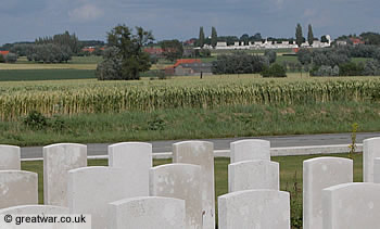
By late September of 1917, the Battle of Passchendaele had been in progress for eight weeks. The lower ground lying south-west of the ridge was the river valley of the Hanebeek stream. At this time the British and German Front Lines were located either side of the stream. Owing to the smashed up state of the ground in this valley the Front Lines, however, were no longer formal lines of trenches. As a result of heavy rain during August and September 1917, in conjunction with the high water table of the area and the fact that this was a river valley, the ground here was a morass of thick, slimy mud. Shell holes from artillery fire were filled with water. The German Front Line position was, therefore, heavily defended by a second position sitting on higher ground to the north-east of it. German trenches and concrete emplacements were built on the forward slope of the ridge.
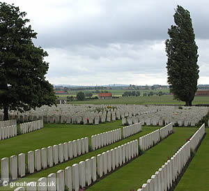
From its position on higher ground the German Army had a magnificent view towards Ypres and across the British positions in the lower ground of the Ypres Salient. This ridge of high ground was extremely important for the German Army to hold on to because it also afforded excellent views to the north and and north east right across their own German rear areas.
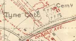
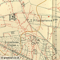
German Positions on Trench Map 28

This section of British Army trench map (Parts of Sheets 20 & 28, Edition 1A) shows the German positions in red corrected to 27th September 1917. This map was used by commanders of the New Zealand Division during the October 1917 battles.
The highlighted square area is the location of Tyne Cot cemetery as it is now. A trench called DAB TRENCH can be seen running north-south. A narrow-gauge railway line is shown leading to DAB TRENCH from a junction at the north-eastern corner of the British Tyne Cot cemetery. Four concrete blockhouses are marked along DAB TRENCH inside the current boundary of Tyne Cot, with an additional bunker shown on the railway line.
Two of the other buildings named after rivers can be seen on this map, namely Seine (bottom left) and Marne (bottom right).
Tyne Cot Cemetery after 1918

After the Armistice of 11 November 1918 the cemetery was enlarged. Over 11,500 graves of British soldiers from the nearby battlefields of Passchendaele and Langemarck were located and brought into this cemetery. The graves from nine small burial grounds in the area were also brought to this site.
|
The cemetery was designed by Sir Herbert Baker. The sculpture was by sculpture by F V Blundstone.
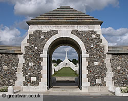
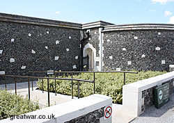
Entrance to the Cemetery
|
Inside the entrance gateway visitors will find the brass box inset into the wall containing the Cemetery Register and the Visitors' Book. The Cross of Sacrifice can be seen through the entrance to the cemetery.
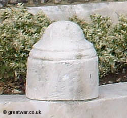
Outside the entrance visitors will notice a number of low Portland stone pillars topped with a sculpted British Army steel helmet.
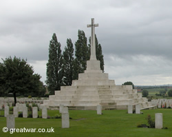
Cross of Sacrifice (Great Cross)
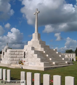
|
King George V visited Tyne Cot cemetery in 1922. At his suggestion the Cross of Sacrifice, also called the Great Cross, was built on the position of one of the concrete German blockhouses which had dominated the ridge.
It was on 4 October 1917 when the 3rd Australian Division captured the ground on which the Tyne Cot cemetery is now located. This was on the first day of the Battle of Broodseinde Ridge, when the II ANZAC Corps, consisting of 3rd Australian Division and the New Zealand Division, went into the attack across the valley of the small Hanebeek river.
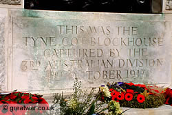
Until the mid 1990s the capture of the blockhouse under which the Cross of Sacrifice is positioned was mistakenly attributed to the 2nd Australian Division on the inscription carved on the base of the cross. In preparation for guiding a battlefield tour to explain the battle and the capture of the Broodseinde Ridge the late Major Bertie Whitmore, MBE, discovered the error on the inscription. His correspondence with the Commonwealth War Graves Commission resulted in an amendment being made in 2000 and the engraved Portland stone tablet was reworked. Visitors may be able to see a faint trace of where the “2nd” was changed to “3rd”.
|
The text inscribed on the front of the Cross of Sacrifice now reads:
THIS WAS THE
TYNE COT BLOCKHOUSE
CAPTURED BY THE
3rd AUSTRALIAN DIVISION
4th OCTOBER 1917
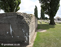
German Blockhouses Retained in the Cemetery
Two other German blockhouses or 'pillboxes' were kept within the boundary of the cemetery and incorporated into the final resting place of so many of the soldiers who had fought and died in their attempt to capture them in 1917.
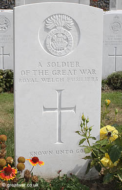
8,367 Unidentified Burials
|
Of the 11,954 burials in Tyne Cot cemetery, 8,367 are unidentified British or Commonwealth servicemen. This is about 70% of the total graves in the cemetery. These graves are marked with headstones which are inscribed with the words “Known unto God”.
Tyne Cot Memorial to the Missing
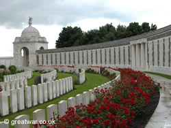 |
Approximately 90,000 British and Commonwealth soldiers died in the Ypres Salient but their identities could not be established at the time of burial or their graves were lost in subsequent fighting. The names of these 90,000 unidentified men of the British and Commonwealth Forces are inscribed on four memorials to the missing in the battle sector known as the Ypres Salient. One of these four memorials is the Tyne Cot Memorial to the Missing.
The Tyne Cot Memorial to the Missing bears the inscribed names of over 34,000 British and New Zealand soldiers whose remains are still missing in the Ypres Salient.
Tyne Cot Memorial to the Missing
Victoria Cross Winners Buried in Tyne Cot Cemetery
|
Three soldiers who were awarded the Victoria Cross (V.C.) are buried in this cemetery. One is Canadian. Two are Australian soldiers, who were awarded the Victoria Cross for their actions during the battles to capture the ridge in October 1917.
Captain Clarence Smith Jeffries, V.C.
Captain Jeffries was serving with the 34th Battalion Australian Infantry during the Battle of Broodseinde Ridge which began on 4 October 1917.
A few days later on 12 October he was taking part in the next phase of the battle when he was killed. He is buried at grave reference Plot XL, Row E, Grave 1.
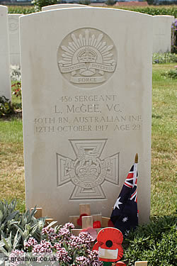
Sergeant Lewis McGee, V.C.
|
Sergeant McGee was serving with the 40th (Tasmanian) Battalion Australian Infantry, taking part in the attack on the Broodseinde Ridge on 4 October 1917. For his gallant actions in knocking out German blockhouses in the vicinity of HAMBURG FARM he was awarded the Victoria Cross.
Sergeant McGee was killed in action on 12 October in the next phase of the Battle of Broodseinde Ridge. He is buried in grave reference Plot XX, Row D, Grave 1.
Private James Peter Robertson, V.C.
Private Robertson was serving with the 27th Battalion Canadian Infantry (Manitoba Regiment) when he was killed on 6 November 1917.
His body is buried in Tyne Cot cemetery at grave reference Plot LVIII, Row D, Grave 26.
Private James Peter Robertson, V.C.
Register of Names in Tyne Cot Cemetery
|
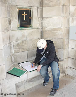
The registers of names buried in Tyne Cot Cemetery are located in the brass box on the wall inside the stone entrance gateway to the cemetery.
The Visitors' Book is also located in this brass box.
As the largest British and Commonwealth military cemetery in the world and with the growth of interest in researching family history many hundreds of people visit the battlefields of the Ypres Salient every year. Tyne Cot cemetery is a special place visited by many of these visitors as individual travellers or with guided tour groups.
The Commonwealth War Graves Commission works hard to maintain the dignified and well-kept appearance of the main grass pathways at the cemetery, given the many pairs of feet now walking through this cemetery.
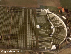
Plan of Tyne Cot Cemetery
|
The plan of Tyne Cot cemetery shows grave plots referred to by Roman numerals.
At the eastern end of the cemetery the location of the Cross of Sacrifice, also known as the Great Cross, and the War Stone can be seen with the randomly spaced graves of the original field burials from October 1917.
The two German bunkers retained in the cemetery are illustrated as two black oblong shapes to the right and left of the entrance building.
The Tyne Cot Memorial to the Missing forms the eastern boundary of the cemetery at the very top of the plan.
Visitors' Centre and Parking at Tyne Cot
|
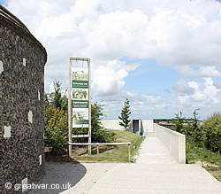
The dramatic growth in the numbers of visitors to the Ypres Salient battlefields, especially to Tyne Cot cemetery, necessitated the construction of a specially designated parking area and a Visitors Centre in 2006.
All tour coaches and minibuses are required to use this access route and are not allowed to park at the front of the cemetery. This has been done for reasons of safety especially at busy visitor times. It also avoids potential danger by larger vehicles creating congestion on the narrow lane at the main entrance of the cemetery.
Vehicle Access and Parking for Tyne Cot Cemetery
A spacious car and coach park is located at the eastern side of the cemetery. There are public toilets (coin operated) at the car park.
Whilst it is still acceptable to park a family car by the cemetery entrance at quiet visitor times, any commercial tour operator with a coach or minibus is no longer allowed to park at the front of the cemetery at any time.
The Visitors' Centre
Visitors walk from the car park along the path towards the Visitors' Centre. The Visitors' Centre contains display panels, items on display and a video film to explain the history of this part of the battlefield.
Visitors' Route into Tyne Cot Cemetery
|
As visitors enter and leave the Visitors Centre they will hear a name spoken aloud by a voice on a continuous speaker system every few seconds. Each name read out is one of the thousands of soldiers commemorated on the Tyne Cot Memorial to the Missing.
Passing through the Visitors Centre visitors can then make their way to the cemetery. The pedestrian route is along a path on the outside of the northern boundary of the cemetery. On reaching the road visitors turn left and follow the cemetery boundary wall to the cemetery's entrance.
Once in the cemetery most visitors walk up the gentle slope in the cemetery along the main path or through the burial plots either side of it towards the Cross of Sacrifice (Great Cross), the War Stone and the Tyne Cot Memorial to the Missing forming the eastern boundary wall.
Visitors' Exit from Tyne Cot Cemetery
The exit route from the cemetery is at the eastern end of the cemetery through the boundary wall and the Memorial to the Missing, signposted to the car park.
Disabled Access to Tyne Cot Cemetery
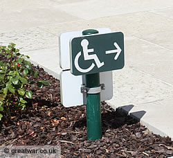
|
Disabled visitors and wheelchairs may enter and exit the cemetery and Memorial to the Missing directly from the car park at the eastern boundary wall.
Discreet, small green signposts guide the way for wheelchairs from the cemetery entrance through the cemetery to avoid any steps.
For additional information and photographs for the Tyne Cot Visitors' Centre go to our page at:
Visitors' Centre at Tyne Cot Cemetery
Location of Tyne Cot Cemetery
Vijfwegestraat, 8980 Zonnebeke, Belgium
Latitude 50.887319; Longitude 3.001040
Tyne Cot Cemetery and Memorial is signposted from the N303/N37 Beselare-Passendale road.
Related Topics
Cemeteries and Memorials in the Ypres Salient
|
For a comprehensive list of the many cemeteries and memorials see our listing, with map locations at:
Cemeteries in the Ypres Salient
Monuments and Memorials in the Ypres Salient
British Army WW1 Trench Maps
For detail about the development of the mapping unit, the reference system, map numbering and examples of trench maps see our illustrated page at:
Acknowledgements
CWCG Plan of the cemetery courtesy of the Commonwealth War Graves Commission.
Some of the cemetery description and history has been sourced by kind permission of The Commonwealth War Graves Commission (CWGC). For more information about the cemeteries and the work of the commission visit the CWGC website:
Website: www.cwgc.org