Yorkshire Trench, Boezinge, Ypres Salient

Discovery of Yorkshire Trench & Dugouts
|
|
In 1992 a group of amateur archeologists named “The Diggers” first discovered the remains of an original British trench. Between 1998 and 2000 they spent many hours digging and examining the trench, which also had tunnelled dugouts. At the time major construction work for new buildings in Ypres' northern industrial zone was also being carried out.
155 Soldiers Found
In addition to many artefacts “The Diggers” discovered the remains of 155 First World War soldiers. The casualties they discovered were British, French and German, lost in battle and never recovered for seventy years.
The project to unearth the trench section featured in a BBC television documentary called “The Forgotten Battlefield”. The soldiers' remains and items found during the dig were passed over to the Commonwealth War Graves Commission (CWGC), the German war graves commission (the Volksbund Deutsche Kriegsgräberfürsorge) and the French Embassy. The museums of In Flanders Fields in Ieper and the Hooghe museum on the Menin Road received some of the artefacts for their archive collections. The remains of the 155 casualties were reburied with full military honours in military cemeteries.
Many of the British casualties discovered here were from an action by the British launched against the German positions on 6 July 1915. The British units involved in the action were in the 11th Brigade of the British 4th Division. The losses to British and German troops were about 600 in total.
On the last day of July in 1917 the Third Battle of Ypres was launched by the British Army in the Ypres Salient. British soldiers in the 38th (Welsh) Division were in this location east of the Ypres-Yser canal at the start of the offensive. On their left was the Guards Division, on their right the 51st Division. The 38th (Welsh) Division launched its attack from this sector on the northern flank of the offensive, making a successful advance of about 4,000 yards as far as Langemarck village by the end of the day. This turned out to be the first of a number of battles to reach the Passchendaele Ridge, and was to become known as the Battle of Pilckem Ridge.
French Soldier Named
It was only possible to identify the name of one of the 155 discovered casualties. He was a French soldier named François Metzinger. He had been serving with the 3rd bis Zouaves de Marche regiment in the French 45th (Algerian) Division. This division had been brought into the French-held sector east of the Ypres-Yser canal from the Arras sector just before the Second Battle of Ypres started on 22 April 1915. His date of death was confirmed as 21 May 1915.
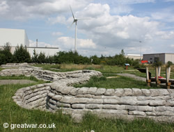
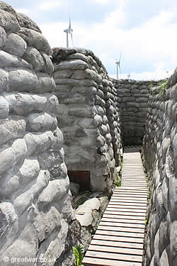
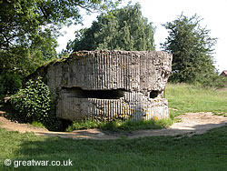
Reconstruction of the Trench System
|
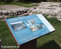
A section of the trench, with entrances to two tunnels and dugouts, has been reconstructed and, therefore, preserved in its original location with concrete sandbags and duckboards. Information boards including photographs and diagrams explain the history of the trench and the area it is in.
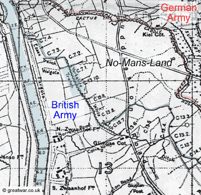
The British Army Trench Map illustrated here shows “Yorkshire Trench” highlighted in blue on the east side of the Ypres-Yser canal. The Trench Map is dated 1st April 1917. Over the following weeks the British Front Line was developed further to the east, closer to the crossroads and the German Front Line in the build-up to the British offensive to be launched on 31 July 1917.
Access to Yorkshire Trench
|
Access to the trench system is available at all hours.
Admission is free.
Location of Yorkshire Trench
The trench is located on the Bargiestraat in the centre of an industrial area to the north of Ypres (close to IVVO).
Latitude N 50° 53' 18" ; Longitude E 2° 52' 26"
Related Topics
Battlefield Remains in the Ypres Salient
|
To see a list of other battle remains in the Ypres area available for public access or to be seen from a public place, see our page at:
Battlefield Remains in the Ypres Salient
British Army Trench Maps
Read our illustrated article about trench maps, how the grid system was developed, the British Army map numbering sequence and where you can view trench maps: