A History of Ypres (Ieper): 1914
 to St. Martin's monastery.")
Ypres in 1914
|
In 1914 the official language of the city was French. The town was officially known by its French name of Ypres, as were most places in the locality.
Ypres was, once again, a prosperous place with a population of about 17-18,000. There was no heavy industry in the region, so the town and its surrounding landscape was rural. The main businesses of the inhabitants were the manufacturing of printed cotton, linen, ribbons, woollen goods, flax, Valenciennes lace and soap-making production. There were tanneries and dye works associated with the trade in cloth. There were many local people who were well-off and generally the local people of Ypres had a good lifestyle.
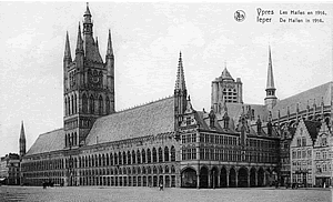
The city itself was still made up of very old buildings, guild houses, narrow streets, the largest market place in Belgium, and the fine Gothic Cloth Hall (Lakenhallen) and belfry.
There was the St. Maartenskerk (the cathedral), cloisters and the bishop's palace, and three churches: the St. Jakobskerk, the St. Pieterskerk, and the St. Niklaaskerk. A convent for the “Arme Klaren” was located in the cloisters of the cathedral. There were several schools, including a school of correction (École de Bienfaissance) on the road to Menin. There was a police station, a prison, health institutions, a laundry, waterworks, a slaughterhouse, theatre, post-office, shops, numerous hotels, pubs and cafés.
Transport and Travel Routes
Surrounded by fertile fields, small farms and a network of villages, Ypres in 1914 was once again a busy focal point for trade routes in the area of south-west Flanders. There were several good routes of transportation to and from the town.
Pavé (cobblestone) roads connected neaby towns: from the north in a clockwise direction there were the towns of Diksmude (Diksmuide), Kortemark, (Roulers) Roeslare, Izegem, (Courtrai) Kortrijk, Menin (Menen), Wervicq (Wervik), Comines-Warneton (Komen-Waasten), Armentières, Poperinghe (now Poperinge) and Furnes (Veurne).
Railway & Tram Routes
In 1914 there was a main-line railway station on the east side of Ypres. With the railway lines and stations constructed across Belgium in the 1850s the first train had arrived at Ypres in March 1854. The line from Poperinghe was connected to the French border in 1870. The railway line from Ypres connected the town to the north, south, east and west. In turn, the town was well-connected to the coast and other parts of Belgium. From Ypres the railway lines ran: north to Tourhout; south to Comines on the French border, connecting Ieper with Armentières and Lille (Rijsel) and also connecting from Comines with Courtrai (Kortrijk) to the east; east to Poperinghe and Abele on the French border, connecting Ypres to Hazebrouck in French Flanders; and east to Roulers (Roeslare).
A network of tram lines also connected Ypres to the north, south, east and west, linking many of the larger villages in the town's outlying areas, and beyond. The tram lines ran from Ypres: to the north to Diksmuide; to the south to Kemmel and Nieuwkerke; to the east to Oostvleteren and on to Furnes (Veurne); to the west to Menin (Menen).
This tram transport system provided easy access for the local inhabitants to travel in and out of the town from the surrounding areas and even from the linking main railway lines further afield as far as the coast and Brugge. This transport system was especially important for traders taking goods to the Ypres' Saturday market and for the people buying things at the market to carry them home.
Canal
The Ypres-Yser (Ieper-Ijzer) canal was busy with boats bringing goods to and from the town.
The building of a second, southern canal from the Iepere river, where it enters the town of Ypres, as far as the Lys (Leie) River at Comines (Komen) on the French border was given the go ahead in 1859. However, the construction encountered major difficulties including landslides at Hollebeke and the collapse of a tunnel. Work was continued on and off, but in June 1913 the collapse of a steel bridge resulted in the final decision to stop the project completely.
Saturday Market
|
Saturday's market day was a busy day in Ypres. The market place in the centre of town would be filled with carts and baskets, with people buying and selling fruit, vegetables and cheese.
Butter Market
The Ypres butter market was famous, and the street named Rue du Beurre (now Boterstraat in Flemish) is from that heritage.
Fish Market
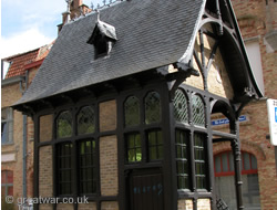
The fish market was held in a street named Vismarkt from 1714. From this time the small boats were not able to sail as far as this point from the quay of the Ypres-Yser canal in the north of the town because the River Ieperleet had been vaulted and was now running under the Vismarkt street. The Minckhuisje was built as a toll booth by the town architect in 1899 and was rebuilt after the war.
Meat Market

|
There was a meat market, formerly in the Vleeshuis near the Cloth Hall. By 1914 it was located in a wide street with railings down the centre of it to tie the cattle to. The street was called Veemarkt and it was near the slaughterhouse north-west of the Cloth Hall.
Wooden Houses & Façades
|
The wooden houses and wooden façades of the Gothic era, which had been plentiful in Ieper until the mid 19th century, had been demolished in large numbers from 1848. One was preserved in its entirety in the upper hall of the Cloth Hall until the Cloth Hall was set on fire in November 1914. That wooden house did not survive the fire.
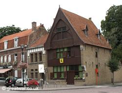
An example of a wooden façade was reconstructed after the 1914-1918 war. It is located near the Lille Gate (Rijselsepoort) on Rijselsestraat.
A Garrison Town
In 1914 Ypres was a garrison town. There was still an infantry barracks inside the town walls in the south-west part of the town. The barracks had fortified shell-proof cellars. These cellars would prove to be useful protection when the First World War came to Ypres. In 1914 the many officers and soldiers based in the infantry barracks provided a good clientele and a steady income for the cafés, shops and businesses in Ypres.
The soldiers drilled on the parade square, known as the Esplanade, next to the infantry barracks. The targets and rifle ranges for military shooting practice (called the Doelen in Dutch) were situated at the buttes in a large wood north-east of Ypres called Polygone de Zonnebeke (or Polygonveld in Dutch) south of Zonnebeke village.
Military Riding Academy
A famous military riding academy (École d'Equitation) in Ypres, established in 1860, attracted high-ranking officers from Belgium and other parts of the world, including South America, to train here as cavalrymen. Built on the site of a former Jesuit monastary the riding school consisted of a building complex with stables, hay barns, a smithy, schooling ring and accommodation for the men.
The presence of well-heeled, rich members of the Belgian and European aristocratic families made Ypres a fashionable place to be seen. The riders practised their riding skills and exercised the horses in the riding school, on the open ground of the Esplanade near the infantry barracks, on the Plaine d'Amour (or Minneplein) in the north of the town, and at a riding arena in Polygone de Zonnebeke Wood (Polygonveld) near Zonnebeke. Squadrons of cavalrymen and gleaming horses would regularly be seen on parade making their way through Ypres, crossing the cobbles of the famous market place (Grande Place or Grote Markt) and passing the Cloth Hall.
Ramparts for Recreation
During the late 1800s there were major changes carried out on the defensive fortifications. This time, however, it was for deconstruction and decommissioning. On the western and northern sides of the town the ramparts and bastions were demolished. It was considered that the ramparts and fortifications were limiting the natural expansion of the town. A wide boulevard had been built on the west side of town opposite the station. One of those streets, Boulevard Malou, was named after one of the Belgian Prime Ministers, who had been born in Ypres, Jules Malou.
The ramparts on the eastern and southern sides of Ypres were, however, more or less left in situ. These ramparts were landscaped, planted with trees and paths were laid. It became a popular place to walk and relax. The ramparts by 1914 were well-used by the local people as recreation areas until the war came to Ypres in the autumn of 1914.
The Moats: Boterplas, Majoorgracht and Kasteelgracht
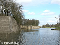 |
In the late 1800s the moats and ditches around in the northern and western sides of the town were filled in during the demolition works to remove some of the rampart fortifications. A narrow stretch of canalised water was left lying from east to west across the north of the town. On the outside of the south-western, southern and eastern fortified stone ramparts three large bodies of water were left, known today as the Boterplas, the Majoorgraacht and the Kasteelgraacht. Fishing in the moats became a popular pastime.
In this new era of peace, when the fortifications were no longer considered necessary to keep out invaders, the early 1900s saw the construction of an outdoor swimming pool called the “Bassin de Natation”. It was formed at the north-eastern corner of the Kasteelgraacht moat.
Town Gates
 |
A feature of the old fortified city had been that there were a number of gates in and out of the town to protect access by road and waterway.
In earlier times the town's road gates had been locked at night, giving access to and from the town during the hours of 05.00 - 21.00 hours in the summer and hours of daylight in winter. Tolls were collected by the gate watchman. In the 1800s until 1865 there were duty taxes due to be paid at the gates for goods entering the town.
There had also been a water gate at the head of the Ypres-Yser (Ieper-Ijzer) canal until it was broken up in about 1884.
By the 1600s four main gates gave access to the major routes from Ypres. These were:
- Diksmuidepoort: gate on the Diksmuidsestraat on the road to Dixmuide to the north.
- Hangwaertpoort, Meensepoort (Porte de Menin): gate on the Rue de Menin also known as the Antwerp Gate until 1853 this was the gate on the road leading to Menin to the east.
- Zuidpoort (1123), Mesenpoort (1214), Rijselpoort: road and water gateway for the road to Mesen (Messines), Leie (Lys) and Rijsel (Lille) to the south.
- Tempelpoort (1200s), Bellepoort (1683): gate on the road to Belle (Bailleul) to the south-west. Rebuilt by Vauban in 1683 in place of the orginal Tempel gate, the Vauban version was broken up in 1896.
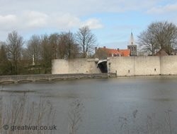
By 1914 only one of the four main town gates, the Mesenpoort/Rijselsepoort (Lille Gate), was surviving in the form of an actual gateway.
Plaine d'Amour (Minneplein)
One special place in Ypres at the turn of the 20th century was at the north-eastern corner of the town. This was called the “Plaine d'Amour” at the time when Ypres was French-speaking. In Dutch it was known as the “Minneplein”. It was a large grassy space located between the old inner and outer fortified town walls. The people of the town used this wide open space for recreation and some animals grazed on it. Today the Plaine d'Amour (Minneplein) is home to a school and a football ground.
Restoration Project from 1895-1914
A major project to restore and refurbish the many fine historical buildings in Ypres was started in 1895. Jules Coomans was appointed as the city's architect for the work. Survey work was carried out on the buildings, restoration work was done and by the summer of 1914 most of the project was complete. The work on the Cloth Hall and belfry was not quite finished, and in the autumn of 1914, when German artillery shells started landing on the town there was wooden scaffolding on the Cloth Hall and belfry.
Antony d'Ypres Photographic Studio
One of the well-known businesses in Ieper in 1914 was the photographic studio on the Rue du Beurre (Boterstraat) run by the photographer family Antony. Madame Léontine Antony-Permbeke (1858-1923) built up the business in Ypres and her two sons Maurice Antony (1883-1963) and Robert Antony (1884-1966) took over the business after her death. The superb collections of photographs by Antony d'Ypres before, during and after the First World War are famous not only for their composition, but for their record of the town as it was before, after the war had arrived and after the war was over.
Tourism to Ypres in 1914
Before the First World War the town of Ypres was popular as a tourist destination with visitors from within Belgium and also from abroad. Many arrived in Ypres by train. The Gothic architecture of the Cloth Hall, the frescoes in the Cloth Hall, historic buildings, the various specialist markets, the lace and the fine collections in the Merghelynckmuseum attracted visitors.
Interestingly, it is known that German officers posing as tourists visited Ypres on cycling tours around the area before the 1914-1918 war. Some of the information they gathered was believed to have been passed to German intelligence for use in planning troop movements in this part of Belgium.
Further Reading
Godenschemering over Ieper: Ieper gezien door de fotografen Léontine, Maurice en Robert Antony, 1893-1930, by Jan Dewilde, 2007, (approximately Euros 38,00). Book about the photographer family Antony from Ypres. Available from the Visitor Centre for Ypres and the Municipal Museums of Ypres.
Acknowledgements
(1) Postcard of the Cloth Hall (Lakenhalle) as it was in 1914 from a set printed in 1930 by Ern. Thill, Bruxelles.
Vesting Ieper, Wandeling in een historisch landschaap, Lieven Stubbe, Dominiek Dendooven, Johan Termote, Philippe Vanderghote
The Reconstruction of Ieper: A Walk Through History, by Dominiek Dendooven and Jan Dewilde
Ieper in oude prentkaarten, by D Masure
Ieper La Carte - de Ieperse Vestinginen in Kaart Gebracht, von Ann Vanrolleghem
Ieper in Stukken, Op't Perron, Trein en tram in Ieper (Exhibition Catalogue), 9 September - 10 October 2011
Ypres and The Battles of Ypres Illustrated Michelin Guides to the Battlefields (1914-1918)
http://www.erfgoedforumbrugge.be/Waggelwater%20spoorwegbrug.html


