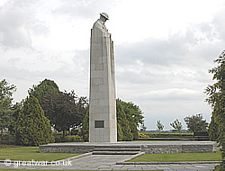
St. Julien Canadian Memorial at Vancouver Corner

|
The memorial commemorates the Canadian 1st Division in action on 22 to 24 April 1915. The Canadian division held its position on the left flank of the British Army after the German Army launched the first ever large-scale gas attack against two French divisions on the left of the Canadians. From the start of the battle at 17.00 hours on 22 April and for the next few days the Canadians were involved in heavy fighting.
In the period when the Canadian Division was in the line from 15 April to 3 May the division suffered heavy casualties of almost 6,000 killed, wounded or missing.
“During the 1st Canadian Division's period in the line (15 April-3 May), Canadian casualties (not including those of the P.P.C.L.I. [Princess Patricia's Canadian Light Infantry]) numbered 208 officers and 5828 other ranks, infantry losses being almost equally distributed between the three brigades.” 1
The casualties in the brigades were recorded as follows:
“The battle casualties recorded for the three Canadian Infantry Brigades from 22nd April to 3rd May were almost equal, for the 1st C.I.B., 1,839, for the 2nd C.I.B. 1,829, for the 3rd C.I.B. 1,838. From 15th April to 17th May battle casualties in the Division numbered 6,341 and there were 1,556 evacuated sick. In the P.P.C.L.I., during the period 10th April to 1st June, the killed, wounded and missing amounted to 658.” 2
Design for the Memorial
|
The design for this memorial was submitted to a competition in 1920, which was looking to find a single design for a national monument to be constructed on eight Canadian battlefield memorial sites granted to Canada by France and Belgium. Five sites were in France and three sites were in Belgium. The Canadian Battlefields Memorials Committee had been set up in 1920 by the Canadian Government. The task of the committee was to carry out the organization and administration for the design competition. 160 ideas were submitted to the competition and 17 were shortlisted. These 17 designs were made up as plaster models by the shortlisted artists, scultors and architects. The winner of the competition, announced in October 1921, was Walter Seymour Allward. His design was for a stone memorial of epic proportions, with twin towers or pylons and 20 sculpted figures. It was decided that Allward's design would be constructed as a national monument on the Vimy Ridge battlefield memorial site.
Frederick Chapman Clemesha, an architect from Regina, had submitted his design for the competition. Clemesha himself had served in the Canadian Corps during the Great War and had been wounded.
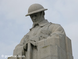
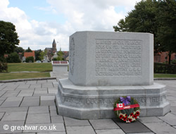
Clemesha's design comprised a single tower of stone with the head and shoulders of a soldier at the top of the tower. The soldier had his head bowed and was in the pose of a serviceman standing with “reversed arms”, that is, he was resting his hands on the rifle butt and the rifle was pointing with its barrel to the ground. Chapman's design was the runner-up in the competition, and his design was chosen to be sited at the battlefield site of St. Julien in memory of the Canadians who fought during the Second Battle of Ypres in the spring of 1915.
The memorial is 11 metres high and constructed from a single shaft of granite. The stone was quarried in the Vosges mountains, the scene of bitter fighting in the mountains between the French and the Germans during the early months of the 1914-1918 war. The granite stone block for the shaft was transported directly to St. Julien in Belgium. The stone block for the head and shoulders bust of the soldier was taken to Brussels where it was carved.
The sculpted figure at the top of this tower of granite is the head and shoulders of a Canadian soldier in his steel helmet. His head is bowed and his hands are resting on the butt of his rifle in the position of “reversed arms”, that is, with the rifle barrel pointing down. The ceremonial custom of reversing the order of things occurs at military funerals and is believed to have been done for the first time at the funeral of the Duke of Marlborough in 1722.
Memorial Inscription
The memorial is inscribed with the words:
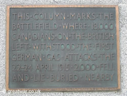
THIS COLUMN MARKS THE BATTLEFIELD WHERE 18,000 CANADIANS ON THE BRITISH LEFT WITHSTOOD THE FIRST GERMAN GAS ATTACKS THE 22ND-24TH OF APRIL 1915. 2,000 FELL AND HERE LIE BURIED
Many of the Canadian soldiers were never recovered and remain as missing in action in the fields or as unidentified graves in the cemeteries around the area of Keerselare near the memorial. The names of the missing Canadians in Flanders, Belgium, are recorded on the Menin Gate Memorial to the Missing in Ypres / Ieper. Those whose bodies were found and buried lie in the military cemeteries in the surrounding battlefield area. Those who died of their wounds would have been laid to rest in cemeteries near to where they were being treated behind the Allied lines.
Menin Gate Memorial to the Missing
Dedication Ceremony
The memorial at St. Julien was unveiled by HRH the Duke of Connaught on 8 July 1923. The former Commander-in-Chief of the Allied Armies, Marshal Ferdinand Foch, was present and paid tribute to the Canadian forces, thanking them for their sacrifice and extending the gratitude of the French nation for their part in the war of 1914-1918.
Canadians Holding the Front Line in April & May 1915
|
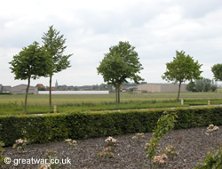
The photograph of the tree-lined road is taken with the memorial behind the camera, looking in a north-westerly direction towards the village of Langemark. Langemark church spire can be seen on the horizon (to the right of the second tree from the left). Langemark was a little way behind the French Front Line on the day of the German gas attack, 22 April 1915. On this photograph the Front Line ran from just north of (to the right of) Langemark and across the horizon to a position about 1.5 kms further along the tree lined road from where this photograph has been taken. Following the gas attack on 22 April the British Front Line was pushed south towards Ypres over the next two weeks past this position at Vancouver Corner. By mid May 1915 the line reached by the German Army was about 1.5 kms to the left along this road where the photograph has been taken.
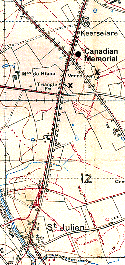
The map section is taken from British Army trench map 28 N.W.2. (Edition 6A) 1:10,000. This 1917 edition of the map is dated July 1917 and at this time Vancouver Corner was behind the German Front Line. The red markings are German trenches or narrow gauge railway lines corrected to 30.6.17. On 22 April 1915 the British Front Line was about 1.5 kms north of Vancouver Corner, which was, therefore, in the British Army area behind the British Front Line.
The black crosses on the map have been added to indicate Triangle Farm (left) and Vancouver Farm (right). Triangle Farm was named presumably because of the shape created by the surrounding roads. This triangular area was also formally named as “The Triangle” on maps from late 1917. Vancouver Farm was likely named by the Canadian 1st Division when they took over this part of the battle front from the French Army in mid April 1915.
For more information about the German gas attack and the part played by the Canadian defence on 22 April 1915 go to our Battle Study: The Second Battle of Ypres at:
Battle Study: Second Battle of YpresVeterans Affairs Canada/Anciens Combattants Canada
To find out more about the role of Canada in the First World War, Canadian ceremonies of Remembrance in Canada and overseas and the work of VAC/ACC visit the website:
Website: www.veterans.gc.ca
Location of Vancouver Corner
Leave Ypres / Ieper on the N313 in the direction of Sint-Jan and St. Julien. About 1.5 kms after Sint-Jan village you come to a T junction where the N313 meets the N38 from the left. Turn right to continue on the N313. In about 2.5 kms you will arrive in St. Julien village. Continue through the village on the N313 for another 600 metres when you will come to crossroads. Continue straight on past this junction and within another 100 metres you will see a right turn (Zonnebekestraat) and the sign for the Canadian Memorial at Vancouver Corner. You will see the tall memorial to your front right. As you turn right into Zonnebekestraat the car park for the memorial is immediately on your left.
Latitude N 50° 53' 58" ; Longitude E 2° 56' 26"
Access to Canadian Memorial Vancouver Corner
This is a site open to the public at all times.
Parking
There is a parking area next to the memorial with easy parking for cars and coaches.
Further Reading

St.Julian: Ypres (Battleground Europe) (paperback)
by Graham Keech
One of the highly acclaimed Battleground Europe guidebook series. Includes maps, photographs and information about what to see on the battlefield today.

Baptism of Fire: The Second Battle of Ypres and the Forging of Canada, April 1915 (paperback)
by Nathan M Greenfield
Account of the Canadian Division in the Ypres Salient during the Second Battle of Ypres.

Magnificent But Not War: The Second Battle of Ypres (paperback)
by John Dixon
A detailed, day by day account of the battle, using personal accounts, regimental histories and war diaries. Illustrated with maps and photographs. Includes the British Order of Battle for the Battle for Hill 60 and for Second Ypres, Officer casualties and a list of Victoria Cross winners.
Related Topics
|
Passchendaele Canadian Memorial (Crest Farm)
Hill 62 (Sanctuary Wood) Canadian Memorial
Canadian National Vimy Memorial, France
Acknowledgements
1 Official History of the Canadian Army in the First World War, Canadian Expeditionary Force, 1914-1919, by Colonel G W Nicholson, CD, p. 92
2 Official History of the Canadian Forces in the Great War 1914-1919, by Colonel A Fortescue Duguid, DSO, BSc, RCA, p. 402
Veterans Affairs Canada/Anciens Combattants Canada.
Website: www.veterans.gc.ca