A History of Ypres (Ieper): A Fortified City

- A Fortified City
- 1678 French Fortifications by Vauban
- Ieperleet River Vaulted
- 1713 Austrians Dismantle the Defences
- 1794: French Capture Ieper
- 1815 Dutch Interventions
- 1852 Military Garrison Leaves Ieper
A Fortified City
Earthwork Defences
Up to the 9th century, the early settlement of Ieper was protected by simple earthworks. As the town grew more wealthy over the centuries the fortifications would be modified again and again. This was either to keep out prospective invaders or to defend possession of it as an “occupied treasure”.
958: A Fortified Castle
In the 10th and 11th centuries the early settlement developed into a larger community based around a fortified castle. In 958 the Count of Flanders, Count Baudoin III (918-962), carried out work on a new castle based on the remains of an earlier structure, which had been damaged by invading Normans.
During the 13th century the County of Flanders was involved in conflicts with France and in 1213 the town was conquered by the French Army. The Countess of Flanders, Joahanna van Constantinopel (c. 1194 - 1244), paid a large ransom to the French to keep Ieper's independence.
1328: Stone Gates & Double Ditch
She Countess decided to build fortifications to strengthen the town's defences. The works consisted of a double moat with earthworks and stone gates. By 1328 there was an inner moat surrounding the main part of the town and an outer moat to enclose five parishes which had grown up on the outskirts of the town outside the inner wall and moat. This work was the foundation of the solid defensive structures built around the town and which were adapted, reconstructed and deconstructed over the following centuries.
From the late 1300s the city went into an economic decline. There was a great loss of life across Europe as a result of the Black Death in 1348.
In 1383 it was caught up in a bloody siege by an English bishop Henry le Despenser. The siege shattered the town, its inhabitants and its infrastructure, causing cruicial damage to the town's ability to continue with its important lace-making economy.
The decline of the town lasted for the next two hundred years. The town's important role in the European cloth trade suffered from disruption to its trade with France and England during the Hundred Years War (1338-1453). Also, Flemish weavers who had left Flanders and settled in the east of England were developing a growing, competitive cloth trade from England.
1388: Burgundian Perimeter Wall
Following the siege of Ypres in 1383 the town lost its independent status and was under the French rule of the Duchy of Burgundy. The Burgundian Duke Philip the Bold (1342-1404) then carried out ten years' work on the town defences from 1388. This work was to strengthen the town's inner defensive moat and earthworks by adding a 4.5 meter high stone wall.
At this time there were nine gates into the town. They included the Boezingepoort, the Diksmuidepoort, the Torhoutspoort, the Hangwaertpoort, the Mesenpoort, teh Tempelpoort, the Boterpoort, the Elverdingepoort and the Steendampoort.
One of the oldest parts of the constructed stone and brick ramparts still surviving today is the town gate known as the Mesenpoort at the time, later called the Rijselpoort (Lille Gate). Although it has undergone numerous modifications over the centuries, the gate in its general form with its round towers dates from 1385.
1669: Spanish Citadel
The troubles for Ieper continued into the 16th century when it declared itself a protestant republic. In 1583 the Catholic Spanish General Alexander Farnese laid siege to the town for a year during the period of the French Wars of Religion (1562-98). Eventually the Spanish conquered the town and began building up the existing defences.
The Spanish added a pentagon-shaped citadel in 1669 on a piece of ground outside the town walls on the east side of Ieper. The citadel was built as an earthwork and intended to be a last point of defence for the defending garrison, should the town walls be breached. It was linked to the rest of the town by a covered tunnel. The Spanish also built some demi-lunes (half-moon shaped structures) on the west and east outside the town walls. These were constructed in front of the length of a curtain wall situated between a bastion at either end of the wall. A bastion is a structure that juts out from the corner or wall of a fort. The Spanish construction work on the defences also expanded the town's inner perimeter wall and fortified defences to include an outlying populated area north of the town.
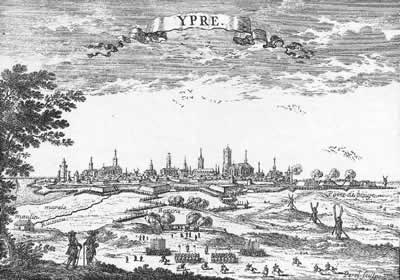
1678: French Fortifications by Vauban
|
In March 1678, the French King Louis XIV (1638-1715) invaded the Spanish Netherlands in a campaign against the Dutch. He first attacked Gent on 9th March, captured it and then attacked Ypres nine days later on the 18th. The townspeople and the Spanish occupying garrison of troops held out against French artillery for a week in the town and the newly constructed citadel. However, on the night of 24th-25th the French attacked again and the town, the citadel and the surviving Spanish troops were captured.
One of the military men directing the French siege operations was a senior military engineer by the name of Sébastien Le Prestre, Seigneur de Vauban (1633-1707). Once the town had fallen to the French he started work on amending the existing defences and fortifications outside the town's inner perimeter wall. He took the Spaniards' earthwork citadel down and in its place built what was called a Hornwork or Corne. This is a structure extending out from the eastern walls with three sides (i.e. two flanks and a front wall with bastions on each of the two corners). It became known as a Hornwork or Corne because the structure jutted out from the perimeter defences like a horn. The Hornwork on the east side of the town was called the Corne d'Anvers (or Hornwork Antwerpen).
Two more Hornworks or Cornes were added to the western side of the town's fortifications, the Corne de' Elverdinge and the Corne d'Bailleul. On the north side of the town he built a fourth Hornwork or Corne called the Basse Ville (Lower Town).
Vauban also built sluice gates on the north and south sides of the town. These would be used to control water in order to flood deliberately the ditches outside the walls and also to fill specially designated areas with water (known as “inundations”). This would form part of the town's defences in case of an attack. The two inundations which were formed south of Ypres were the Inondation de Bailleul and the Inondation de Messine.
In 1682 Vauban returned to Ypres to continue his work. This time he focused on changes to the inner fortifications. He considered that the town walls needed strengthening in a major way on all sides, except for the south-western section. This was, in his opinion, already well protected by the marshy approach to it. He designed what is called a bastion trace around the town, meaning that the encircling town walls consisted of curtain walls and bastions, creating a shape known as a star fortification. He incorporated casemates and tunnels into the ramparts, and battery emplacements for cannons at the bastion locations.
Vauban's prolific work on town fortifications can still be seen in many cities and forts in France and Belgium, many of which are located in the French and Belgian border regions and the battlefields of the 1914-1918 Western Front.
Ieperleet River Vaulted
In the late 17th century the two arms of the Ieperlee river flowing through the centre of Ieper were again adapted by man. From 1686 the entire length of the water course through the centre of the city was vaulted from the Rijselpoort (the Lille Gate) in the south of the town to the Ieper-Ijzer (Ypres-Yser) canal quay in the north. Buildings were later built on top of the vaulted river and from then on it flowed, and still does, underneath the centre of the town.
1713: Austrians Dismantle the Defences
|
The Austrian Habsburg dynasty took over Ieper in 1713. The year of 1782-83 saw changes made to the fortifications by Emporer Joseph II (1741-1790). However, this time the ruler was unhappy about spending large amounts of money on the defences at Ieper and he gave orders to dismantle some of the structures built by Vauban, weakening the town's defences.
Ironically for Emperor Joseph the Austrians were driven out of Flanders and Ieper following an uprising by the people of the southern Netherlands, including Flanders, called the Brabant Revolution (1789 and 1790).
1794: French Capture Ieper
The town came under attack by the French Army in its campaign against Flanders in 1794. In June of that year the town's defences could not withstand the enemy attacks and it fell under French control once again.
1815: Dutch Interventions
The defeat of Emporer Napoléon I (1769-1821) in 1815 at the Battle of Waterloo meant that the annexation of Ieper to the French Empire was also over. Flanders subsequently joined with the Netherlands in a United Kingdom of the Netherlands.
In an attempt to strengthen the town defences again, as it lay in a strategically important location between the Dutch and the French borders, the Dutch spent fifteen years carrying out a major series of works on the fortifications and military complexes in the town. One of the major works they carried out was to build a new bombproof ammunition store with walls at a thickness of 2-3 metres. These works by the Dutch are known as the “Dutch Interventions”.
1852: Military Garrison Leaves Ieper
In 1830 a revolution led to the founding of an independent Belgian nation in October of that year. On 26 June 1831 Leopold I (1790-1865) was declared the first King of Belgium. With the founding of the new Belgian nation the work to build up the defences of Ieper came to a halt. Also, the military garrison left the town in 1852.
The Statesman and Prime Minister Jules Edouard Xavier Malou (1810-1886) had been born in Ypres. He put forward a case to the Belgian government that Ieper should receive financial compensation for the great gap created in the town's economy as a result of the loss of the hundreds of military men. He made the specific point that the town's brewers had lost the majority of their customers! To the relief of many of the town's businesses a military presence did return to the town before the turn of the century.
There is still a garrison of Belgian Army troops at Ieper. The barracks is located in the southern outskirts of the town on the road to Mesen (Messines).
Acknowledgements
(1) Image and header photo detail courtesy of Wikimedia Commons with image details at Siege of Ypre, 1678, source: http://commons.wikimedia.org/wiki/File%3ASi%C3%A8ge_d'Ypres_en_1678.jpg. Attribution: See page for author [Public domain], via Wikimedia Commons
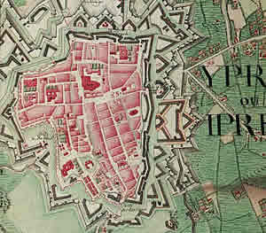
(2) Image courtesy of Wikimedia Commons with image details at http://en.wikipedia.org/wiki/File:Ieper,_Belgium_;_Ferraris_Map.jpg
Vesting Ieper, Wandeling in een historisch landschaap, Lieven Stubbe, Dominiek Dendooven, Johan Termote, Philippe Vanderghote
The Reconstruction of Ieper: A Walk Through History, by Dominiek Dendooven and Jan Dewilde
Ieper La Carte - de Ieperse Vestinginen in Kaart Gebracht, von Ann Vanrolleghem
Ypres and The Battles of Ypres Illustrated Michelin Guides to the Battlefields (1914-1918)
Grateful thanks to the expertise on Vauban and his forts at http://www.fortified-places.com/ypres/
en.wikipedia.org/wiki/Siege_of_Ypres_%281678%29
http://www.erfgoedforumbrugge.be/Waggelwater%20spoorwegbrug.html


