Sanctuary Wood Museum (Hill 62)

After the First World War a farmer returned to reclaim his land in and around what was left of the wood he had left in 1914. A section of the original wood and the trenches in it were cleared of debris and casualties but generally the farmer left a section of a British trench system as he found it.
|
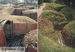
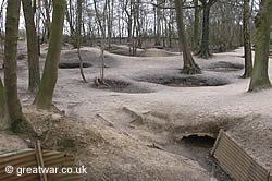
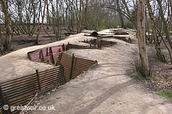
This site is now one of the few places on the Ypres Salient battlefields where an original trench layout can be seen in some semblance of what it might have looked like. Elsewhere the trenches were filled in and ploughed over by returning farmers leaving only the occasional chalky outline of what had once been there.
In the last decade there has been a large increase in visitors to the Ypres Salient, and many have, of course, included a visit to the trenches at Sanctuary Wood. In the 1990s the trenches were covered in grass and the whole site was overgrown with undergrowth. Interestingly, nowadays the ground around the trench line has been visited by so many pairs of feet that it is mostly bald with no grass or undergrowth. The photograph on the far right shows how the trenches looked just a few years ago.
The need for the preservation of battlefield areas makes for an interesting discussion. The natural desire to be allowed to walk freely amongst historical remains such as these trenches is one side of the argument, the possibility that they will be damaged in so doing is another. It's been a topic of discussion for some years already by battlefield historians, local authorities and the people who live with the scarred landscape all around them. Sanctuary Wood is a fascinating example of how such war remains bring together the local people who own the ground and live with them daily, the people who come in their thousands each year to see them, historians who debate whether these trench remains are original or not, and the people who want to find ways to preserve endangered WW1 battlefield remains.
The Sanctuary Wood trench museum is privately owned by the grandson of the farmer who reclaimed his land in 1919 when the local people returned to Ypres.
Tunnel and Trenches Cleared
|
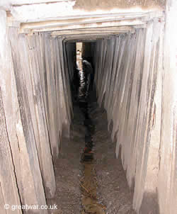
In the early 1980s some ground collapsed and revealed the previously undiscovered 4 foot high 'L' shaped tunnel built by British Army engineers.
Since its discovery the tunnel has been cleared and lighting installed making it possible for people with suitable footwear to walk through.
More recently the trenches have been renovated in places using corrugated iron to hold up the trench sides. Since the early 1990s the “untouched” preserved state the site was in has changed dramatically as a result of an ever growing number of visitors walking through the wood. The thick undergrowth that used to carpet the wood has virtually disappeared.
Battlefield Relics and Museum Collection
|
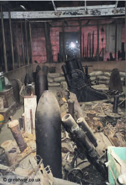
There are numerous battlefield relics and items of interest to be seen near to the entrance of the indoor part of the museum.
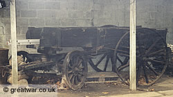
British Army Cook's Wagon
These include a rare example of a British Army Cook's Wagon. This wagon was given a treatment of wood preserver in the 1980s by volunteers from the British Army's Royal Corps of Transport serving near Antwerp.
German Stone Grave Markers
There are several German grave markers reclaimed from the battlefields. These were removed from their original burial location after the burials were presumably moved from outlying battlefield burial plots into a formal German military cemetery during the battlefield clearance after 1918.
Indoor Museum
|
The museum collection contains equipment removed from the battlefield in the vicinity of Sanctuary Wood.
Three Dimensional Photos
On entering the museum through the café visitors will be in a room with display cases on tables in the centre of the room. Many interesting photographs are arranged on the walls.
In this room there is also a large and rare collection of three dimensional photo images inside special viewing boxes. These 3D photographs were produced after the war and are absorbing and absolutely fascinating to look through.
Please note that some of the 3D photographs may contain images unsuitable for younger children.
Historical Background to Sanctuary Wood
|
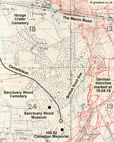
The fighting between the British and German Armies arrived in the peaceful countryside of Flanders east of the town of Ypres in the late autumn of 1914. It was during the First Battle of Ypres in October and November 1914 that the British Army used the cover of a large wood south of the Ypres-Menin road near Hooge for tending to their casualties. At that time the wood was to the west of and behind the British fighting line. It is believed to have been given its name on the 1914-1918 British Army battlefield maps, called Trench Maps, for that very reason; it was providing a place of sanctuary to the wounded.
This section of a British Army trench map shows Sanctuary Wood with the German front line trenches marked in red in 16 April 1916 (Trench map 28 N.W.4: trenches corrected to 16-4-16, scale 1:10,000). As this is a British map the German trenches (red) are shown in detail. The British front line (the blue dashed line) is shown as an approximate location without detailed trenches for security reasons in case the map fell into German possession.
On German battlefield maps the small wood west of Sanctuary Wood is called Zuaven Wäldchen, which translates into English as Zouave Wood, as on the British trench map. A zouave was the name for a soldier from the French Zouave Regiment. The German maps name a small stream flowing through the wood from north of the Menin Road as Zuaven Bach (English translation: Zouave Stream). Interestingly, German battlefield maps do not give a German name for Sanctuary Wood, in spite of it being such a large wood.
|
By mid November 1914 the First Battle of Ypres drew to a close and the British and German front line trenches became static in the eastern part of Sanctuary Wood. Front line and support trenches for both the German and the British Armies remained in and around the wood until July 1917 when the British launched an offensive on the German lines for the Third Battle of Ypres (known as the Battle of Passchendaele) on 31 July 1917.
In 1918 the German Army pushed the Allied Armies back towards Ypres again and the two front lines were located to the west of Sanctuary Wood close to Ypres. This meant that the Sanctuary Wood area was now east of and behind the German front line. The movement of front lines backwards and forwards over the same ground is typical of the WWI fighting during the four years of war in the Ypres Salient. This accounts for the absolute destruction of parts of the landscape over and over, and the reason why the bodies of so many thousands of soldiers from all sides have never been found.
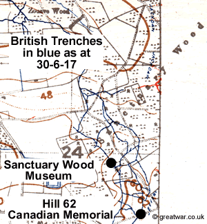
This section of map is taken from British Army trench map 28 N.W. (Edition 6A) with trenches corrected to a later date of 30.6.17 (scale 1:20,000). It shows British trenches marked in blue in Sanctuary Wood in a little more detail than the map above.
Canadalaan to Hill 62
|
Canadalaan is the name of a purpose-built road from the Menin Road leading to the Hill 62 Canadian Memorial. There are also a few private houses and the Sanctuary Wood (Hill 62) Museum along this road. Translated into English Canadalaan means “Canada Avenue”.
The avenue is lined with Canadian maple trees. During the war there had been an idea to plant an avenue of maple trees leading up to a memorial in the area of Vancouver Corner in memory of the Canadian soldiers who perished in the German gas attacks during the Second Battle of Ypres in April 1915.
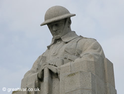
However, after the war it was decided instead to build a maple lined avenue, a road which had not existed before WWI, to provide access to the Canadian Memorial commemorating the June 1916 Battle of Mount Sorrel at Hill 62.
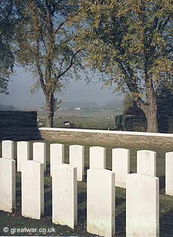
The photograph is taken from Sanctuary Wood Cemetery, looking in a northly direction between two of the Canadian maple trees to Hooge in the distance on the Menin Road.
For information about The Second Battle of Ypres in 1915 see our battle study at:
Visiting Sanctuary Wood (Hill 62) Museum
 |
The museum at Sanctuary Wood is privately owned and the following information may be subject to change without notice.
Souvenirs and Books
A selection of books, postcards and memorabilia is for sale in the café.
Opening Hours
|
Open daily: 09.00 to 18.00 hours; Saturdays open 09.00 to 19.00 hours.
Visitors are recommended to allow at least one hour before closing time when starting a visit to the wood and the museum.
Admission Charges
Admission charges may be subject to change without notice.
Groups can make a reservation. See contact details below.
Access
Visitors are advised that the ground in the wood is uneven and some of the wood may not be accessible for wheelchair users.
If you wish to go down the tunnel you may need to wear boots or waterproof shoes as it can get very muddy. Though the tunnel is usually lit you may like to bring a torch to be able to see some of the details inside.
At certain times of the year the Sanctuary Wood museum can be very busy with groups and individual visitors. This is mainly in the summer months and around 11 November.
Location of Sanctuary Wood (Hill 62) Museum
Leave Ypres / Ieper from the eastern exit (through the Menin Gate Memorial to the Missing). At the traffic lights turn right onto the N8 Ieper-Menen road (The Menin Road). In approximately 2 kilometres you will come to a roundabout. This is the location of the crossroads known famously as “Hellfire Corner” to the British Army. Go straight over the roundabout, taking the N8 Meenseweg-Meensestraat in the direction of Menen. Drive for approximately one kilometre and on the right you will see a signpost directing you to the right into the road named Canadalaan for the Sanctuary Wood Museum (Hill 62).
Latitude N 50° 50' 12" ; Longitude E 2° 56' 46"
Contact Details for Sanctuary Wood Museum
Sanctuary Wood Museum (Hill 62), Canadalaan 26, B-8902 Zillebeke, Belgium
Telephone: +32 (0)57 46 63 73
Email: hill62@skynet.be
Website: www.hill62trenches.be
Further Reading

Sanctuary Wood and Hooge (paperback)
by Nigel Cave
Guidebook in the excellent Battleground Europe series. The story of the battles at Sanctuary Wood and Hooge includes photographs and maps.
Related Topics
Canadian St. Julien Memorial at Vancouver Corner
|
Memorial to the Canadian soldiers killed and wounded in the German gas attacks during the Second Battle of Ypres in April and May 1915:
Canadian St. Julien Memorial at Vancouver Corner
British Army Trench Maps
For a detailed page of information and illustrations about British Army trench maps go to:
Visiting the Ypres Salient Battlefields
|
Find out more about what there is to see on the Ypres Salient battlefields: